Glass Coaster > Africa > Uganda > Maps
Glass Coaster : Map of Kenya and Uganda


![]()
Home Decor from Mary Evans Picture Library
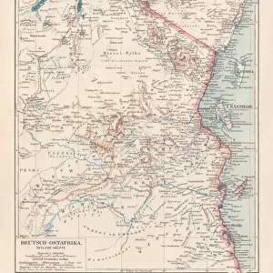
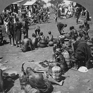
Map of Kenya and Uganda
Map of Kenya Uganda boundary, 1926 Date: 1926
Mary Evans Picture Library makes available wonderful images created for people to enjoy over the centuries
Media ID 7401295
© Mary Evans Picture Library 2015 - https://copyrighthub.org/s0/hub1/creation/maryevans/MaryEvansPictureID/10473848
Glass Coaster
Individual Glass Coaster. Stylish and elegant polished safety glass, toughened and heat resistant (10x10cm, 7mm thick). Price shown is per individual coaster.
Individual Glass Coaster. Elegant polished safety toughened glass and heat resistant, matching Place Mats are also available
Estimated Image Size (if not cropped) is 7.6cm x 7.6cm (3" x 3")
Estimated Product Size is 10cm x 10cm (3.9" x 3.9")
These are individually made so all sizes are approximate
Artwork printed orientated as per the preview above, with landscape (horizontal) or portrait (vertical) orientation to match the source image.
FEATURES IN THESE COLLECTIONS
> Africa
> Kenya
> Related Images
> Africa
> Related Images
> Africa
> Uganda
> Related Images
> Maps and Charts
> Related Images
> Mary Evans Prints Online
> National Archives
EDITORS COMMENTS
1. Title: "A Fragment of African History: The Map of Kenya and Uganda Border, 1926" This vintage map print showcases the borders of Kenya and Uganda as they appeared in 1926. The intricate details of the topography, rivers, and major cities are rendered with meticulous precision, offering a glimpse into the geographical makeup of East Africa during the 1920s. The map's age, with its worn edges and subtle discoloration, adds a sense of historical depth and authenticity. The map's creation coincides with a pivotal period in African history. In the aftermath of World War I, European powers redrew the continent's borders, often disregarding the traditional territories and ethnic affiliations of the indigenous populations. This map reflects the new political realities, with Kenya and Uganda emerging as distinct entities under British rule. Kenya, located to the south, was a British protectorate since 1895, while Uganda, to the north, was a British protectorate since 1894. The map highlights major cities such as Nairobi, Mombasa, and Kisumu in Kenya, and Kampala, Gulu, and Jinja in Uganda. The Nile River, a vital water source and historic trade route, is depicted flowing through both countries. This map serves as a poignant reminder of the complex history of Africa and the intricate web of political, cultural, and geographical influences that have shaped its modern borders. It invites us to reflect on the past and consider the ongoing implications of colonial legacies in contemporary Africa. The map's intricate details and historical significance make it an essential addition to any collection focused on African history, geography, or cartography. Its aged appearance adds a sense of nostalgia and authenticity, transporting us back to a time when the world was being reshaped through the lens of European imperialism.
MADE IN THE UK
Safe Shipping with 30 Day Money Back Guarantee
FREE PERSONALISATION*
We are proud to offer a range of customisation features including Personalised Captions, Color Filters and Picture Zoom Tools
SECURE PAYMENTS
We happily accept a wide range of payment options so you can pay for the things you need in the way that is most convenient for you
* Options may vary by product and licensing agreement. Zoomed Pictures can be adjusted in the Basket.