Glass Coaster > Europe > Italy > Sicily > Palermo
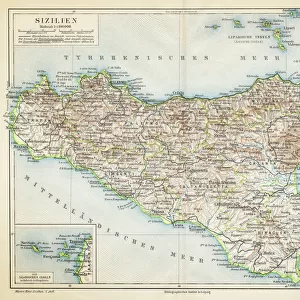
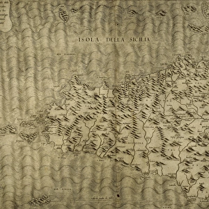
Glass Coaster : Map of Sicily by G. H. Davis


![]()
Home Decor from Mary Evans Picture Library
Map of Sicily by G. H. Davis
A contour map of Sicily, giving the shortest air distances from Cape Bon and Malta. At this stage in the Second World War it was a British front-line objective in Axis eyes, a target of major air attacks on Palermo and other strategic points, and the stepping stone to Italy. Date: 1943
Mary Evans Picture Library makes available wonderful images created for people to enjoy over the centuries
Media ID 14133379
© Illustrated London News Ltd/Mary Evans
1943 Allied Allies Attack Attacks Axis Cape Contour Davis Distance Distances Focal Focus Ionian Major Malta Maps Mediterranean Palermo Points Sicilian Sicily Stepping Strategic Target Tyrrhenian Objective
Glass Coaster
Individual Glass Coaster. Stylish and elegant polished safety glass, toughened and heat resistant (10x10cm, 7mm thick). Price shown is per individual coaster.
Individual Glass Coaster. Elegant polished safety toughened glass and heat resistant, matching Place Mats are also available
Estimated Image Size (if not cropped) is 5.3cm x 7.6cm (2.1" x 3")
Estimated Product Size is 10cm x 10cm (3.9" x 3.9")
These are individually made so all sizes are approximate
Artwork printed orientated as per the preview above, with portrait (vertical) orientation to match the source image.
FEATURES IN THESE COLLECTIONS
> Europe
> France
> Canton
> Allier
> Europe
> Italy
> Related Images
> Europe
> Italy
> Sicily
> Palermo
> Europe
> Italy
> Sicily
> Related Images
> Europe
> Malta
> Related Images
EDITORS COMMENTS
This contour map of Sicily, created by renowned cartographer G.H. Davis in 1943, offers a unique glimpse into the strategic importance of the island during the Second World War. At this pivotal moment in history, Sicily served as a British front-line objective in Axis eyes, a target of major air attacks on Palermo and other strategic points, and the stepping stone to Italy. The map, titled "Map of Sicily: Showing the Shortest Air Distances from Cape Bon and Malta," highlights the island's location in the Mediterranean Sea, bordered by the Ionian and Tyrrhenian Seas. The contour lines provide a detailed representation of the island's topography, while the inclusion of air distances from Cape Bon and Malta underscores Sicily's significance as a key military and logistical hub. During the war, Sicily was a focal point of Allied and Axis attention. The island's capture by the Allies in July 1943 marked a turning point in the war, as it provided a base for further operations in Italy and the Mediterranean. The map reflects the intense focus on Sicily as a military objective, with the major air attacks on Palermo and other strategic points evident in the damage and destruction depicted on the map. This historical map provides a fascinating window into the wartime history of Sicily and the Mediterranean region, offering insights into the strategic considerations and military operations that shaped the course of the Second World War in Europe.
MADE IN THE UK
Safe Shipping with 30 Day Money Back Guarantee
FREE PERSONALISATION*
We are proud to offer a range of customisation features including Personalised Captions, Color Filters and Picture Zoom Tools
SECURE PAYMENTS
We happily accept a wide range of payment options so you can pay for the things you need in the way that is most convenient for you
* Options may vary by product and licensing agreement. Zoomed Pictures can be adjusted in the Basket.