Glass Coaster > Europe > United Kingdom > Maps
Glass Coaster : Historical World Events map 1971 UK version


![]()
Home Decor from Map Marketing
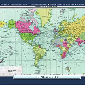
Historical World Events map 1971 UK version
A world map originally published in 1971, reproduced from the internationally famousCollins Bartholomew World Through Timehistoric cartographic archive. A perfect reminder of how the world looked in 1971. The map is framed in a stylish text border containing highlights of significant events from 1971
Media ID 19949409
© Design Map Marketing Ltd, Mapping Collins Bartholomew
Glass Coaster
Individual Glass Coaster. Stylish and elegant polished safety glass, toughened and heat resistant (10x10cm, 7mm thick). Price shown is per individual coaster.
Individual Glass Coaster. Elegant polished safety toughened glass and heat resistant, matching Place Mats are also available
Estimated Image Size (if not cropped) is 7.6cm x 5.2cm (3" x 2")
Estimated Product Size is 10cm x 10cm (3.9" x 3.9")
These are individually made so all sizes are approximate
Artwork printed orientated as per the preview above, with landscape (horizontal) orientation to match the source image.
FEATURES IN THESE COLLECTIONS
> Europe
> United Kingdom
> Maps
> Maps and Charts
> Early Maps
> Maps and Charts
> Related Images
> Maps and Charts
> World
> Map Marketing
> Historical World Maps
> Map Marketing
> UK Maps
MADE IN THE UK
Safe Shipping with 30 Day Money Back Guarantee
FREE PERSONALISATION*
We are proud to offer a range of customisation features including Personalised Captions, Color Filters and Picture Zoom Tools
SECURE PAYMENTS
We happily accept a wide range of payment options so you can pay for the things you need in the way that is most convenient for you
* Options may vary by product and licensing agreement. Zoomed Pictures can be adjusted in the Basket.