Glass Coaster > Granger Art on Demand > Maps
Glass Coaster : WORLD MAP, c1492. World map showing only the Eastern Hemisphere


![]()
Home Decor from Granger
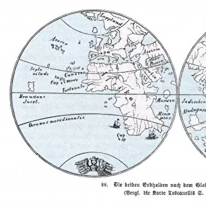
WORLD MAP, c1492. World map showing only the Eastern Hemisphere
WORLD MAP, c1492.
World map showing only the Eastern Hemisphere. One of the first maps to depict the Cape of Good Hope, Madagascar and Zanzibar. The distortions in this map made an attempt to reach the East Indies by sailing west seem safer and easier than sailing around Africa. Attributed to Francesco Rosselli, c1492
Granger holds millions of images spanning more than 25,000 years of world history, from before the Stone Age to the dawn of the Space Age
Media ID 12321173
1492 Age Of Discovery Asia Cape Of Good Hope Eastern Europe Francesco Hemisphere New World World Zanzibar Rosselli
Glass Coaster
Individual Glass Coaster. Stylish and elegant polished safety glass, toughened and heat resistant (10x10cm, 7mm thick). Price shown is per individual coaster.
Individual Glass Coaster. Elegant polished safety toughened glass and heat resistant, matching Place Mats are also available
Estimated Image Size (if not cropped) is 7.6cm x 5.6cm (3" x 2.2")
Estimated Product Size is 10cm x 10cm (3.9" x 3.9")
These are individually made so all sizes are approximate
Artwork printed orientated as per the preview above, with landscape (horizontal) orientation to match the source image.
EDITORS COMMENTS
This print showcases a remarkable piece of history - the WORLD MAP, c1492. It takes us back to the age of discovery when explorers were venturing into uncharted territories. This particular map focuses solely on the Eastern Hemisphere, providing a unique perspective from that era. Created by Francesco Rosselli around 1492 during the Renaissance period, this map stands as one of the earliest depictions to feature significant landmarks such as the Cape of Good Hope, Madagascar, and Zanzibar. Its distortions intentionally aimed to convince sailors that reaching the East Indies by sailing west was a safer and easier route compared to circumnavigating Africa. The intricate details and craftsmanship in this Italian-made map are truly awe-inspiring. As we gaze upon it, we can almost imagine ourselves transported back in time when these lands were yet to be fully explored. With its rich historical significance and connection to an era marked by curiosity and exploration, this World Map serves as a reminder of humanity's insatiable thirst for knowledge. It encapsulates an important chapter in our collective journey towards understanding our world better. Whether you are an avid history enthusiast or simply appreciate art that tells stories from centuries past, this print is sure to captivate your imagination with its depiction of a world on the brink of discovery.
MADE IN THE UK
Safe Shipping with 30 Day Money Back Guarantee
FREE PERSONALISATION*
We are proud to offer a range of customisation features including Personalised Captions, Color Filters and Picture Zoom Tools
SECURE PAYMENTS
We happily accept a wide range of payment options so you can pay for the things you need in the way that is most convenient for you
* Options may vary by product and licensing agreement. Zoomed Pictures can be adjusted in the Basket.