Glass Coaster > North America > United States of America > New York > New York > Maps
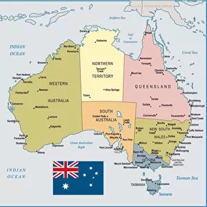
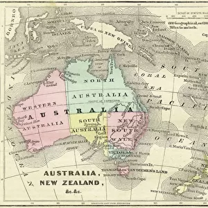
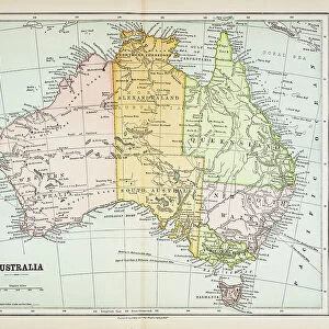
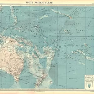
Glass Coaster : Australia map 1875


![]()
Home Decor from Fine Art Storehouse
Australia map 1875
The Independent Course Comprehensive Geography by James Monteith, A.S. Barnes & Co, New York & Chicago 1875
Unleash your creativity and transform your space into a visual masterpiece!
THEPALMER
Media ID 13612257
© This content is subject to copyright
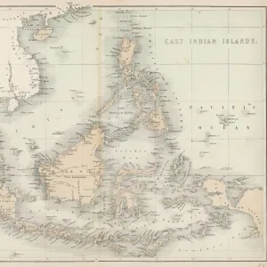
Australasia Australia Indonesia Malaysia New Zealand Oceania Pacific Pacific Ocean Papua Papua New Guinea Queensland Solomon Tasmania Drawing Art Product
Glass Coaster
Individual Glass Coaster. Stylish and elegant polished safety glass, toughened and heat resistant (10x10cm, 7mm thick). Price shown is per individual coaster.
Individual Glass Coaster. Elegant polished safety toughened glass and heat resistant, matching Place Mats are also available
Estimated Image Size (if not cropped) is 7.6cm x 5.3cm (3" x 2.1")
Estimated Product Size is 10cm x 10cm (3.9" x 3.9")
These are individually made so all sizes are approximate
Artwork printed orientated as per the preview above, with landscape (horizontal) orientation to match the source image.
FEATURES IN THESE COLLECTIONS
> Fine Art Storehouse
> The Magical World of Illustration
> Palmer Illustrated Collection
> Fine Art Storehouse
> Map
> Historical Maps
> Arts
> Artists
> O
> Oceanic Oceanic
> Asia
> Indonesia
> Related Images
> Asia
> Malaysia
> Related Images
> Maps and Charts
> Related Images
> North America
> United States of America
> Maps
> North America
> United States of America
> New York
> New York
> Maps
EDITORS COMMENTS
This print takes us back in time to the year 1875, showcasing an intricately detailed map of Australia. The map is a part of "The Independent Course Comprehensive Geography" by James Monteith, published by A. S. Barnes & Co in New York and Chicago. It offers a glimpse into the geographical knowledge and cartographic techniques prevalent during that era. Every element on this vintage map tells a story - from Malaysia and Tasmania to Australasia and Indonesia, it encompasses not only Australia but also its surrounding regions like New Zealand, Oceania, Pacific Ocean, Papua New Guinea, Queensland, Solomon Islands, and more. The artist's skillful engraving and etching techniques bring out the fine details with precision. As we observe this historical artifact closely, we can appreciate the artistry involved in creating such maps before modern technology took over. The delicate lines and intricate patterns showcase the dedication put forth by THEPALMER in preserving this piece of history through their photography. This print serves as a reminder of how our understanding of geography has evolved over time while highlighting the importance of preserving these invaluable artifacts for future generations to learn from.
MADE IN THE UK
Safe Shipping with 30 Day Money Back Guarantee
FREE PERSONALISATION*
We are proud to offer a range of customisation features including Personalised Captions, Color Filters and Picture Zoom Tools
SECURE PAYMENTS
We happily accept a wide range of payment options so you can pay for the things you need in the way that is most convenient for you
* Options may vary by product and licensing agreement. Zoomed Pictures can be adjusted in the Basket.