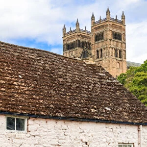
Glass Coaster > Europe > United Kingdom > England > Durham > Durham
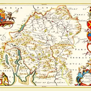
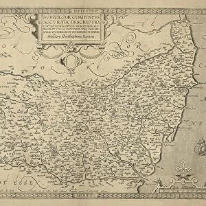
Glass Coaster : Map of Durham, 1777 (hand coloured engraving)
")
")


![]()
Home Decor from Fine Art Finder
Map of Durham, 1777 (hand coloured engraving)
BAL16024 Map of Durham, 1777 (hand coloured engraving) by Kitchin, Thomas (fl.1777); Map House, London, UK; English, out of copyright
Media ID 12733814
© www.bridgemanimages.com
Glass Coaster
Individual Glass Coaster. Stylish and elegant polished safety glass, toughened and heat resistant (10x10cm, 7mm thick). Price shown is per individual coaster.
Individual Glass Coaster. Elegant polished safety toughened glass and heat resistant, matching Place Mats are also available
Estimated Image Size (if not cropped) is 7.6cm x 5.8cm (3" x 2.3")
Estimated Product Size is 10cm x 10cm (3.9" x 3.9")
These are individually made so all sizes are approximate
Artwork printed orientated as per the preview above, with landscape (horizontal) orientation to match the source image.
FEATURES IN THESE COLLECTIONS
> Animals
> Mammals
> Muridae
> House Mouse
> Arts
> Artists
> H
> Thomas Hand
> Arts
> Artists
> K
> Thomas Kitchin
> Europe
> United Kingdom
> England
> Durham
> Durham
> Europe
> United Kingdom
> England
> London
> Related Images
> Europe
> United Kingdom
> England
> Maps
> Europe
> United Kingdom
> England
> Posters
> Europe
> United Kingdom
> England
> Related Images
> Europe
> United Kingdom
> Maps
EDITORS COMMENTS
This hand-coloured engraving from 1777 takes us on a journey back in time to the enchanting city of Durham, England. Created by Thomas Kitchin and preserved at Map House in London, this intricate map showcases the remarkable artistry and precision of cartography during that era. As we gaze upon this historical gem, our eyes are immediately drawn to the exquisite details meticulously etched onto its surface. Every street, building, and landmark is delicately depicted with utmost care and accuracy. The vibrant colours added by skilled hands bring life to the streets of Durham, transporting us into a world long gone. The map offers a fascinating glimpse into what life was like in this bustling English city over two centuries ago. It invites us to explore its winding roads, discover hidden corners, and imagine the stories that unfolded within these ancient walls. Beyond being an artistic masterpiece, this print serves as a valuable historical document that captures Durham's essence during a pivotal moment in time. It reminds us of how cities evolve and change throughout history while still retaining their unique charm. Whether you are an avid collector or simply appreciate fine art with historical significance, this hand-coloured engraving will undoubtedly captivate your imagination and transport you back to the enchanting streets of old Durham.
MADE IN THE UK
Safe Shipping with 30 Day Money Back Guarantee
FREE PERSONALISATION*
We are proud to offer a range of customisation features including Personalised Captions, Color Filters and Picture Zoom Tools
SECURE PAYMENTS
We happily accept a wide range of payment options so you can pay for the things you need in the way that is most convenient for you
* Options may vary by product and licensing agreement. Zoomed Pictures can be adjusted in the Basket.