Glass Coaster > Europe > United Kingdom > England > London > Towns > Hatton
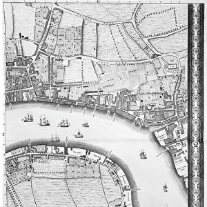
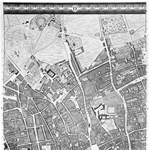
Glass Coaster : A Map of Clerkenwell, City of London, 1746 (engraving)
")
")


![]()
Home Decor from Fine Art Finder
A Map of Clerkenwell, City of London, 1746 (engraving)
XJF438448 A Map of Clerkenwell, City of London, 1746 (engraving) by Rocque, John (c.1704-d.1762); Private Collection; British, out of copyright
Media ID 12881152
© www.bridgemanimages.com
Aerial View Aldersgate Street Area Barbican Charterhouse Square Christs Hospital Clerkenwell Finsbury Grays Inn Lane Hatton Garden High Holborn Newgate Street The City West Smithfield Barts Fleet Market
Glass Coaster
Individual Glass Coaster. Stylish and elegant polished safety glass, toughened and heat resistant (10x10cm, 7mm thick). Price shown is per individual coaster.
Individual Glass Coaster. Elegant polished safety toughened glass and heat resistant, matching Place Mats are also available
Estimated Image Size (if not cropped) is 5.6cm x 7.6cm (2.2" x 3")
Estimated Product Size is 10cm x 10cm (3.9" x 3.9")
These are individually made so all sizes are approximate
Artwork printed orientated as per the preview above, with portrait (vertical) orientation to match the source image.
FEATURES IN THESE COLLECTIONS
> Fine Art Finder
> Artists
> John Rocque
> Aerial Photography
> Related Images
> Arts
> Artists
> R
> John Rocque
> Arts
> Landscape paintings
> Waterfall and river artworks
> River artworks
> Arts
> Portraits
> Pop art gallery
> Street art portraits
> Europe
> United Kingdom
> England
> London
> Boroughs
> City of London
> Europe
> United Kingdom
> England
> London
> Hospitals
> Europe
> United Kingdom
> England
> London
> Related Images
> Europe
> United Kingdom
> England
> London
> Sights
> New River
> Europe
> United Kingdom
> England
> London
> Towns
> Hatton
> Europe
> United Kingdom
> England
> London
> Towns
> West Green
EDITORS COMMENTS
This print showcases a historical treasure, "A Map of Clerkenwell, City of London, 1746". Created by the talented engraver John Rocque, this piece takes us back in time to explore the intricate details of Clerkenwell and its surrounding areas. The map offers a bird's-eye view of the cityscape, allowing us to navigate through iconic landmarks such as High Holborn, Hatton Garden, West Smithfield, Barbican, Finsbury, and Newgate Street. It also highlights significant institutions like Christ's Hospital and St. Bartholomew's Hospital (affectionately known as Barts), which have stood the test of time. As we gaze at this aerial perspective captured over two centuries ago, we can't help but marvel at how much has changed since then. The bustling Fleet Market and Goswell Street are now transformed into modern urban landscapes while Aldersgate Street retains its historic charm. Charterhouse Square stands proudly amidst green spaces that have witnessed generations come and go. Grays Inn Lane winds its way through the heart of Clerkenwell with an air of timeless elegance. This remarkable engraving not only serves as a visual delight for history enthusiasts but also provides valuable insights into the evolution of one of London's oldest neighborhoods. Its presence in private collections ensures that this precious artifact is preserved for future generations to appreciate and learn from.
MADE IN THE UK
Safe Shipping with 30 Day Money Back Guarantee
FREE PERSONALISATION*
We are proud to offer a range of customisation features including Personalised Captions, Color Filters and Picture Zoom Tools
SECURE PAYMENTS
We happily accept a wide range of payment options so you can pay for the things you need in the way that is most convenient for you
* Options may vary by product and licensing agreement. Zoomed Pictures can be adjusted in the Basket.