Glass Coaster > Arts > Artists > M > Gerardus Mercator
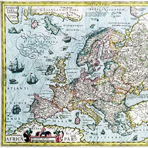
Glass Coaster : The North Polar regions, 1595 (engraving, 1596)
")
")


![]()
Home Decor from Fine Art Finder
The North Polar regions, 1595 (engraving, 1596)
LRI4716648 The North Polar regions, 1595 (engraving, 1596) by Mercator, Gerardus (1512-94); Private Collection; (add.info.: Septentrionalium Terrarum descriptio, 1595: The Nord Polar regions - in " Atlas Ssive Corsmographicae Meditationes" by Gerard Mercator (Gerard de Kremer - Gerhard Kremer - Gerardus Mercator) (1512-1594), Duisburg 1596); Luisa Ricciarini; Flemish, out of copyright
Media ID 23717510
© Luisa Ricciarini / Bridgeman Images
Atlas Book North Pole Geographical Map
Glass Coaster
Individual Glass Coaster. Stylish and elegant polished safety glass, toughened and heat resistant (10x10cm, 7mm thick). Price shown is per individual coaster.
Individual Glass Coaster. Elegant polished safety toughened glass and heat resistant, matching Place Mats are also available
Estimated Image Size (if not cropped) is 7.6cm x 7.2cm (3" x 2.8")
Estimated Product Size is 10cm x 10cm (3.9" x 3.9")
These are individually made so all sizes are approximate
Artwork printed orientated as per the preview above, with landscape (horizontal) orientation to match the source image.
FEATURES IN THESE COLLECTIONS
> Fine Art Finder
> Artists
> Gerardus Mercator
> Arts
> Artists
> M
> Gerardus Mercator
> Maps and Charts
> Gerardus Mercator's Cartographic
> Maps and Charts
> Related Images
EDITORS COMMENTS
This print showcases "The North Polar regions, 1595" an exquisite engraving created by Gerardus Mercator in 1596. The artwork is part of a private collection and depicts the Septentrionalium Terrarum descriptio, a geographical map featured in Mercator's renowned "Atlas Ssive Corsmographicae Meditationes". Gerardus Mercator, also known as Gerard de Kremer or Gerhard Kremer, was a Flemish cartographer who lived from 1512 to 1594. His meticulous attention to detail and innovative projection technique revolutionized mapmaking during the Renaissance period. "The North Polar regions" engraving provides viewers with a glimpse into the intricate world of early cartography. It offers an intriguing depiction of the geography surrounding the north pole during that era. This historical artifact not only serves as a valuable resource for understanding past explorations but also showcases Mercator's exceptional skill in creating accurate and visually stunning maps. Luisa Ricciarini has masterfully captured this remarkable piece through her lens, allowing us to appreciate its beauty and significance even more deeply. With its delicate lines and rich details, this print transports us back in time to explore the uncharted territories of centuries ago. As we gaze upon this mesmerizing image, we are reminded of both humanity's insatiable curiosity about our planet and our collective desire to unravel its mysteries.
MADE IN THE UK
Safe Shipping with 30 Day Money Back Guarantee
FREE PERSONALISATION*
We are proud to offer a range of customisation features including Personalised Captions, Color Filters and Picture Zoom Tools
SECURE PAYMENTS
We happily accept a wide range of payment options so you can pay for the things you need in the way that is most convenient for you
* Options may vary by product and licensing agreement. Zoomed Pictures can be adjusted in the Basket.