Glass Coaster > Europe > France > Paris > Maps
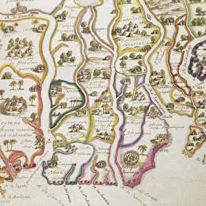
Glass Coaster : Map of the Coast of Africa and the River Gambia, 1622 (coloured engraving)
")
")


![]()
Home Decor from Fine Art Finder
Map of the Coast of Africa and the River Gambia, 1622 (coloured engraving)
884601 Map of the Coast of Africa and the River Gambia, 1622 (coloured engraving) by French School, (17th century); Bibliotheque Nationale, Paris, France; (add.info.: Carte de la cA'te d Afrique depuis la riviAre de Gambie jusqu A celle de Cherbe ou Madre Bombe); eArchives Charmet; French, out of copyright
Media ID 22225118
© Archives Charmet / Bridgeman Images
Birds Eye View Ports Senegal Senegalese Settlement Settlements Villages
Glass Coaster
Individual Glass Coaster. Stylish and elegant polished safety glass, toughened and heat resistant (10x10cm, 7mm thick). Price shown is per individual coaster.
Individual Glass Coaster. Elegant polished safety toughened glass and heat resistant, matching Place Mats are also available
Estimated Image Size (if not cropped) is 7.6cm x 5.9cm (3" x 2.3")
Estimated Product Size is 10cm x 10cm (3.9" x 3.9")
These are individually made so all sizes are approximate
Artwork printed orientated as per the preview above, with landscape (horizontal) orientation to match the source image.
FEATURES IN THESE COLLECTIONS
> Fine Art Finder
> Artists
> French School
> Africa
> The Gambia
> Maps
> Africa
> Related Images
> Africa
> Senegal
> Related Images
> Arts
> Landscape paintings
> Waterfall and river artworks
> River artworks
> Europe
> France
> Paris
> Maps
> Europe
> France
> Paris
> Related Images
EDITORS COMMENTS
This coloured engraving from 1622 offers a glimpse into the intricate and diverse coastline of Africa, specifically focusing on the River Gambia. The map, created by an anonymous French School artist in the 17th century, is now housed in the Bibliotheque Nationale in Paris, France. The detailed print showcases various settlements and villages along the coast, providing a unique perspective of African life during this time period. From Senegal to Cherbe or Madre Bombe, every port and river is meticulously depicted with precision and accuracy. The birds-eye view offered by this engraving allows viewers to immerse themselves in the maritime world of Africa's coastal regions. As one explores this historic map, they can almost hear the sounds of bustling activity within each settlement as trade routes flourish along these shores. Not only does this print serve as a valuable historical document but it also highlights the artistic skill involved in creating such intricate engravings. Every stroke captures not just geographical features but also cultural nuances that define these African landscapes. With its vibrant colours and attention to detail, this Map of the Coast of Africa and the River Gambia transports us back to a time when exploration was at its peak. It stands as a testament to both human curiosity and artistic craftsmanship while offering us an invaluable window into our shared past.
MADE IN THE UK
Safe Shipping with 30 Day Money Back Guarantee
FREE PERSONALISATION*
We are proud to offer a range of customisation features including Personalised Captions, Color Filters and Picture Zoom Tools
SECURE PAYMENTS
We happily accept a wide range of payment options so you can pay for the things you need in the way that is most convenient for you
* Options may vary by product and licensing agreement. Zoomed Pictures can be adjusted in the Basket.