Framed Print > Europe > United Kingdom > England > Sussex > Eartham
Framed Print : Eartham tithe map, 1840


![]()
Framed Photos from West Sussex County Council
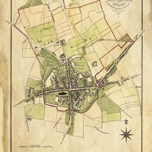
Eartham tithe map, 1840
Enlarged from the Inclosure Map made in 1813. Revised and corrected to the present time for the Commutation of the Tithes of the Parish of Eartham. By J. Butler, Chichester. 13.3 in. to 1m. 40 × 25
Tithe Award Map Collection
West Sussex Record Office Ref No: TD/W44
West Sussex County Council Record Office contains a fascinating history of the county of West Sussex, England
Media ID 10716291
© West Sussex County Council - All Rights Reserved
1840s 19th Century Historical Mapping South Of England
22"x18" (58x48cm) Modern Frame
Step back in time with our stunning Framed Print from the Media Storehouse collection. This captivating piece showcases the Eartham Tithe Map from 1840, originally created by J. Butler in Chichester. Meticulously enlarged from the Inclosure Map of 1813, this revised and corrected version provides a fascinating glimpse into the history of the Eartham parish. Add an air of sophistication and historical charm to your home or office with this beautiful, high-quality framed print. Perfect for history enthusiasts, genealogists, or anyone who appreciates the beauty and richness of our past.
Wood effect frame, card mounted, 16x12 archival quality photo print. Overall outside dimensions 22x18 inches (58x48cm). Environmentally and ozone friendly, 40mm wide x 15mm Polycore® moulding has the look of real wood, is durable and light and easy to hang. Biodegradable and made with non-chlorinated gases (no toxic fumes) it is efficient; producing 100 tons of polystyrene can save 300 tons of trees! Prints are glazed with lightweight, shatterproof, optical clarity acrylic (providing the same general protection from the environment as glass). The back is stapled hardboard with a sawtooth hanger attached. Note: To minimise original artwork cropping, for optimum layout, and to ensure print is secure, the visible print may be marginally smaller
Contemporary Framed and Mounted Prints - Professionally Made and Ready to Hang
Estimated Image Size (if not cropped) is 26.1cm x 39.6cm (10.3" x 15.6")
Estimated Product Size is 47.8cm x 57.9cm (18.8" x 22.8")
These are individually made so all sizes are approximate
Artwork printed orientated as per the preview above, with portrait (vertical) orientation to match the source image.
FEATURES IN THESE COLLECTIONS
> Europe
> United Kingdom
> England
> Chichester
> Europe
> United Kingdom
> England
> Maps
> Europe
> United Kingdom
> England
> Sussex
> Chichester
> Europe
> United Kingdom
> England
> Sussex
> Eartham
> Europe
> United Kingdom
> England
> Sussex
> Related Images
> Europe
> United Kingdom
> England
> West Sussex
> Chichester
> Europe
> United Kingdom
> England
> West Sussex
> Related Images
> Maps and Charts
> Early Maps
> Maps and Charts
> Related Images
> West Sussex County Council
> West Sussex Record Office
> Tithe Award Maps, 1808-1859
EDITORS COMMENTS
This print showcases the Eartham tithe map from 1840, which was enlarged from the Inclosure Map created in 1813. The meticulous revisions and corrections made by J. Butler of Chichester bring this historical piece up to date for the Commutation of the Tithes of the Parish of Eartham. Measuring at an impressive scale of 13.3 inches to 1 meter, this map offers a detailed glimpse into the past. Part of the esteemed Tithe Award Map Collection held at West Sussex Record Office, this artifact provides valuable insights into land ownership and usage during the early decades of the 19th century in southern England. Its historical significance cannot be overstated as it sheds light on how communities were structured and cultivated during that era. Preserved with utmost care, this print serves as a testament to West Sussex County Council's commitment to safeguarding our rich heritage for future generations. It is important to note that any commercial use or affiliation is not associated with this image; rather, its purpose lies in education and appreciation for our shared history. Whether you are a historian seeking deeper understanding or simply intrigued by cartography, this remarkable piece invites you to explore Eartham's landscape through time and immerse yourself in its fascinating narrative.
MADE IN THE UK
Safe Shipping with 30 Day Money Back Guarantee
FREE PERSONALISATION*
We are proud to offer a range of customisation features including Personalised Captions, Color Filters and Picture Zoom Tools
SECURE PAYMENTS
We happily accept a wide range of payment options so you can pay for the things you need in the way that is most convenient for you
* Options may vary by product and licensing agreement. Zoomed Pictures can be adjusted in the Basket.