Framed Print > Asia > Iran > Maps
Framed Print : Map of Iran


![]()
Framed Photos from Universal Images Group (UIG)
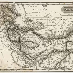
Map of Iran
Universal Images Group (UIG) manages distribution for many leading specialist agencies worldwide
Media ID 9539837
© Dorling Kindersley/UIG
Country Iran Middle Eastern Persia
30"x26" (78x68cm) Modern Frame
Wood effect frame, card mounted, 24x20 archival quality photo print. Overall outside dimensions 30x26 inches (76x68cm). Environmentally and ozone friendly, 43mm wide x 32mm Polycore® moulding has the look of real wood, is durable and light and easy to hang. Biodegradable and made with non-chlorinated gases (no toxic fumes) it is efficient; producing 100 tons of polystyrene can save 300 tons of trees! Prints are glazed with lightweight, shatterproof, optical clarity acrylic (providing the same general protection from the environment as glass). The back is stapled hardboard with a sawtooth hanger attached. Note: To minimise original artwork cropping, for optimum layout, and to ensure print is secure, the visible print may be marginally smaller
Contemporary Framed and Mounted Prints - Professionally Made and Ready to Hang
Estimated Image Size (if not cropped) is 59.9cm x 59.9cm (23.6" x 23.6")
Estimated Product Size is 68.2cm x 78.2cm (26.9" x 30.8")
These are individually made so all sizes are approximate
Artwork printed orientated as per the preview above, with landscape (horizontal) or portrait (vertical) orientation to match the source image.
FEATURES IN THESE COLLECTIONS
> Asia
> Iran
> Related Images
> Maps and Charts
> Related Images
> Universal Images Group (UIG)
> Illustrations
> Illustrations 1
EDITORS COMMENTS
This print showcases a beautifully detailed "Map of Iran" created by the renowned cartography experts at Dorling Kindersley. With its vibrant colors and intricate illustrations, this map effortlessly captures the essence of this ancient land. Stretching from the Caspian Sea in the north to the Persian Gulf in the south, Iran's rich geography is expertly depicted on this print. From towering mountain ranges to vast deserts and fertile plains, every corner of this diverse country is meticulously portrayed. The map also highlights major cities, rivers, and landmarks that have shaped Iran's history and culture. As you gaze upon this stunning piece of artistry, you are transported into a world where past meets present. The historical significance of Persia shines through as you trace your fingers along ancient trade routes and explore legendary archaeological sites like Persepolis. Whether you are an avid traveler planning your next adventure or simply fascinated by Middle Eastern culture, this map will undoubtedly ignite your wanderlust. Its impeccable attention to detail makes it not only a valuable educational resource but also an aesthetically pleasing addition to any space. So immerse yourself in the wonders of Iran with this extraordinary print from Universal Images Group (UIG). Let it serve as a reminder that there is always more to discover beyond what meets the eye – both on maps and in life itself.
MADE IN THE UK
Safe Shipping with 30 Day Money Back Guarantee
FREE PERSONALISATION*
We are proud to offer a range of customisation features including Personalised Captions, Color Filters and Picture Zoom Tools
SECURE PAYMENTS
We happily accept a wide range of payment options so you can pay for the things you need in the way that is most convenient for you
* Options may vary by product and licensing agreement. Zoomed Pictures can be adjusted in the Basket.