Framed Print > Universal Images Group (UIG) > Art > Painting, Sculpture & Prints > Cartography
Framed Print : Map of Tunis, Tunisia, from Civitates Orbis Terrarum by Georg Braun and Franz Hogenberg, engraving


![]()
Framed Photos from Universal Images Group (UIG)
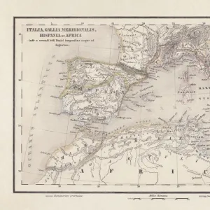
Map of Tunis, Tunisia, from Civitates Orbis Terrarum by Georg Braun and Franz Hogenberg, engraving
Cartography, Tunisia, 16th century. Map of Tunis. From Civitates Orbis Terrarum by Georg Braun (1541-1622) and Franz Hogenberg (1540-1590), Cologne. Engraving
Universal Images Group (UIG) manages distribution for many leading specialist agencies worldwide
Media ID 9501363
© DEA / A. DAGLI ORTI
16th Century Civitates Orbis Terrarum Colonialism Elevated View Franz Hogenberg Georg Braun Guidance Harbor Sailing Ship Town Townscape Tunis Tunisia Western Script
14"x12" (38x32cm) Modern Frame
Step back in time with our exquisite Framed Prints from Media Storehouse, featuring this captivating map of Tunis, Tunisia, from the renowned atlas "Civitates Orbis Terrarum" by Georg Braun and Franz Hogenberg. Dating back to the 16th century, this intricately detailed engraving showcases the rich cartographic traditions of the time. Bring a piece of history into your home or office with this stunning and authentic work of art.
Wood effect frame, card mounted, 10x8 archival quality photo print. Overall outside dimensions 14x12 inches (38x32cm). Environmentally and ozone friendly, 40mm wide x 15mm Polycore® moulding has the look of real wood, is durable and light and easy to hang. Biodegradable and made with non-chlorinated gases (no toxic fumes) it is efficient; producing 100 tons of polystyrene can save 300 tons of trees! Prints are glazed with lightweight, shatterproof, optical clarity acrylic (providing the same general protection from the environment as glass). The back is stapled hardboard with a sawtooth hanger attached. Note: To minimise original artwork cropping, for optimum layout, and to ensure print is secure, the visible print may be marginally smaller
Contemporary Framed and Mounted Prints - Professionally Made and Ready to Hang
Estimated Image Size (if not cropped) is 24.4cm x 19cm (9.6" x 7.5")
Estimated Product Size is 37.6cm x 32.5cm (14.8" x 12.8")
These are individually made so all sizes are approximate
Artwork printed orientated as per the preview above, with landscape (horizontal) orientation to match the source image.
EDITORS COMMENTS
This print showcases a remarkable piece of history - the Map of Tunis, Tunisia from Civitates Orbis Terrarum by Georg Braun and Franz Hogenberg. Created in the 16th century, this engraving offers a fascinating glimpse into the colonialism era and serves as an invaluable cartographic artifact. The map beautifully captures the townscape of Tunis with its intricate architecture and bustling harbor. From an elevated view, we can appreciate the strategic location of this bay city that made it a hub for exploration and trade during that time. The presence of a majestic sailing ship further emphasizes its significance as a maritime center. With Western script guiding our eyes through its detailed streets and landmarks, this map provides valuable insights into the historical development of Tunis. It invites us to imagine what life was like in this vibrant town centuries ago. As an illustration and painting merged with cartography, this engraving is not only visually stunning but also serves as a testament to human curiosity and quest for knowledge during the Renaissance period. Its horizontal format allows us to immerse ourselves fully in its rich details while appreciating every stroke made by Georg Braun and Franz Hogenberg. This print is more than just an image; it represents our connection to history, reminding us how far we have come while honoring those who paved the way before us.
MADE IN THE UK
Safe Shipping with 30 Day Money Back Guarantee
FREE PERSONALISATION*
We are proud to offer a range of customisation features including Personalised Captions, Color Filters and Picture Zoom Tools
SECURE PAYMENTS
We happily accept a wide range of payment options so you can pay for the things you need in the way that is most convenient for you
* Options may vary by product and licensing agreement. Zoomed Pictures can be adjusted in the Basket.