Framed Print > Aerial Photography > Africa
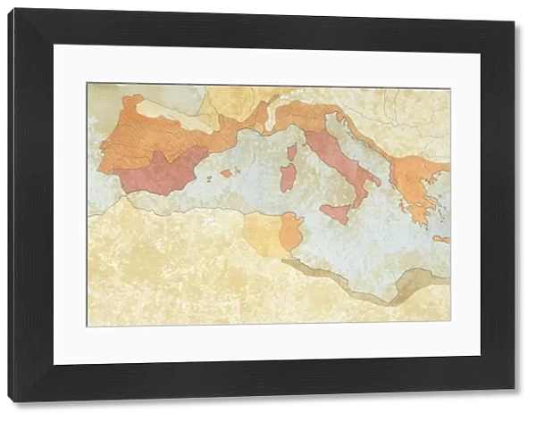
Framed Print : Map of the territories under Roman rule after the Second Punic War (218-201 BC), including Spain, Northern Africa, Greece, Asia Minor and Egypt, drawing
![]()

Framed Photos from Universal Images Group (UIG)
Map of the territories under Roman rule after the Second Punic War (218-201 BC), including Spain, Northern Africa, Greece, Asia Minor and Egypt, drawing
Cartography - Roman Civilization. Map of the territories under Roman rule after the Second Punic War (218-201 b.C.), including Spain, Northern Africa, Greece, Asia Minor and Egypt
Universal Images Group (UIG) manages distribution for many leading specialist agencies worldwide
Media ID 9472381
3rd Century Ad Aerial View Colored Background Drawing Mediterranean Sea Second Punic War
22"x18" (58x48cm) Modern Frame
Step back in time with our stunning Framed Print from Media Storehouse, featuring a captivating map of the Roman Empire's territories after the Second Punic War (218-201 BC). This intricately detailed drawing from Universal Images Group (UIG) beautifully illustrates the extent of Rome's power during this pivotal period in history. From Spain in the west to Egypt in the east, and encompassing Greece, Asia Minor, and Northern Africa, this map is a testament to the Roman civilization's remarkable expansion. Add an air of sophistication and historical intrigue to your home or office with this exquisite and authentic-looking framed print. A perfect addition to any collection devoted to ancient history or cartography.
Wood effect frame, card mounted, 16x12 archival quality photo print. Overall outside dimensions 22x18 inches (58x48cm). Environmentally and ozone friendly, 40mm wide x 15mm Polycore® moulding has the look of real wood, is durable and light and easy to hang. Biodegradable and made with non-chlorinated gases (no toxic fumes) it is efficient; producing 100 tons of polystyrene can save 300 tons of trees! Prints are glazed with lightweight, shatterproof, optical clarity acrylic (providing the same general protection from the environment as glass). The back is stapled hardboard with a sawtooth hanger attached. Note: To minimise original artwork cropping, for optimum layout, and to ensure print is secure, the visible print may be marginally smaller
Contemporary Framed and Mounted Prints - Professionally Made and Ready to Hang
Estimated Image Size (if not cropped) is 39.6cm x 26.8cm (15.6" x 10.6")
Estimated Product Size is 57.9cm x 47.8cm (22.8" x 18.8")
These are individually made so all sizes are approximate
Artwork printed orientated as per the preview above, with landscape (horizontal) orientation to match the source image.
FEATURES IN THESE COLLECTIONS
> Aerial Photography
> Related Images
> Africa
> Egypt
> Related Images
> Arts
> Artists
> R
> Roman Roman
> Europe
> Greece
> Aerial Views
> Universal Images Group (UIG)
> Art
> Archeology
EDITORS COMMENTS
This print showcases a meticulously detailed map of the territories under Roman rule after the Second Punic War, which took place from 218 to 201 BC. Spanning across vast regions including Spain, Northern Africa, Greece, Asia Minor, and Egypt, this ancient cartographic masterpiece offers a fascinating glimpse into the expansive reach of the Roman civilization during its peak. The aerial view presented in this horizontal illustration allows us to appreciate the strategic positioning of these conquered lands around the Mediterranean Sea. The colored background adds depth and vibrancy to an already mesmerizing depiction of history. With no people present in this image, our focus is solely on exploring and understanding how Rome's dominance shaped these diverse regions. As we delve into this visual representation of ancient times, it becomes evident that this map holds immense historical significance. It serves as a testament to Rome's military prowess and ambition for expansion beyond its own borders. Moreover, it highlights key territories gained through victory over Carthage in one of history's most significant conflicts - the Second Punic War. Whether you are an avid historian or simply captivated by ancient civilizations, this remarkable print from Universal Images Group (UIG) transports you back in time with its intricate details and rich narrative. Let your imagination soar as you explore each corner of Roman influence on this beautifully crafted piece of artistry.
MADE IN THE UK
Safe Shipping with 30 Day Money Back Guarantee
FREE PERSONALISATION*
We are proud to offer a range of customisation features including Personalised Captions, Color Filters and Picture Zoom Tools
SECURE PAYMENTS
We happily accept a wide range of payment options so you can pay for the things you need in the way that is most convenient for you
* Options may vary by product and licensing agreement. Zoomed Pictures can be adjusted in the Basket.

