Framed Print > Europe > United Kingdom > England > Staffordshire > Stoke on Trent
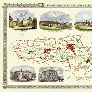
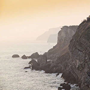
Framed Print : County Map of Staffordshire, c. 1777


![]()
Framed Photos from Sheffield City Archives
County Map of Staffordshire, c. 1777
From The Large English Atlas: or, a new set of map of all the counties of England and Wales drawn from the several surveys which have been hitherto been published. With three general maps of England, Scotland and Ireland, from the latest and best authorities, by Emanuel Bowen, Thomas Kitchin and others. London, printed and sold by T. Bowles, [c.1777]
Original at Sheffield Libraries: 912 STF
Sheffield City Archives and Local Studies Library has an unrivalled collection of images of Sheffield, England
Media ID 25501499
© Sheffield City Council - All Rights Reserved
Antique Map Bowens Map County Map Emanuel Bowen Old Map Thomas Kitchin Burton On Trent Cannock Cheadle Leek Lichfield Newcastle Under Lyme Rugeley Stafford Staffordshire Stoke On Trent Tamworth Uttoxeter
14"x12" (38x32cm) Modern Frame
Discover the rich history of Staffordshire with our stunning Framed Print from Media Storehouse. This beautiful reproduction showcases an intricately detailed County Map of Staffordshire from 1777, taken from The Large English Atlas. Originating from the Sheffield City Archives, this antique map transports you back in time, offering a captivating glimpse into the cartography of the past. Hang this exquisite piece in your home or office to add a touch of historical charm and sophistication to your space.
Wood effect frame, card mounted, 10x8 archival quality photo print. Overall outside dimensions 14x12 inches (38x32cm). Environmentally and ozone friendly, 40mm wide x 15mm Polycore® moulding has the look of real wood, is durable and light and easy to hang. Biodegradable and made with non-chlorinated gases (no toxic fumes) it is efficient; producing 100 tons of polystyrene can save 300 tons of trees! Prints are glazed with lightweight, shatterproof, optical clarity acrylic (providing the same general protection from the environment as glass). The back is stapled hardboard with a sawtooth hanger attached. Note: To minimise original artwork cropping, for optimum layout, and to ensure print is secure, the visible print may be marginally smaller
Contemporary Framed and Mounted Prints - Professionally Made and Ready to Hang
Estimated Image Size (if not cropped) is 18.5cm x 24.4cm (7.3" x 9.6")
Estimated Product Size is 32.5cm x 37.6cm (12.8" x 14.8")
These are individually made so all sizes are approximate
Artwork printed orientated as per the preview above, with portrait (vertical) orientation to match the source image.
FEATURES IN THESE COLLECTIONS
> Europe
> United Kingdom
> England
> Staffordshire
> Stoke on Trent
> Sheffield City Archives
> Maps and Plans
> Bowen's County Maps, c. 1777
EDITORS COMMENTS
This print showcases a County Map of Staffordshire, dating back to the year 1777. A true relic from history, this antique map was originally featured in "The Large English Atlas: or, a new set of maps of all the counties of England and Wales". Created by renowned cartographers Emanuel Bowen, Thomas Kitchin, and others, this masterpiece offers an invaluable glimpse into the past. London-based publisher T. Bowles brought this remarkable piece to life for eager audiences over two centuries ago. Today, it finds its home at Sheffield Libraries in their esteemed collection (912 STF). The intricate details on this map allow us to explore various towns and cities within Staffordshire such as Stafford itself, Stoke-on-Trent, Tamworth, Newcastle-under-Lyme, Burton-on-Trent, Lichfield, Cannock, Burntwood Kidsgrove Rugeley Leek Uttoxeter Cheadle. As we delve into each corner of this historic county through the lens of Emanuel Bowen and Thomas Kitchin's expertise in cartography; we are transported back to a time when these places were bustling with life yet untouched by modern development. This visual treasure serves as a reminder of our rich heritage and provides an opportunity for both historians and enthusiasts alike to appreciate the beauty that lies within old maps like these
MADE IN THE UK
Safe Shipping with 30 Day Money Back Guarantee
FREE PERSONALISATION*
We are proud to offer a range of customisation features including Personalised Captions, Color Filters and Picture Zoom Tools
SECURE PAYMENTS
We happily accept a wide range of payment options so you can pay for the things you need in the way that is most convenient for you
* Options may vary by product and licensing agreement. Zoomed Pictures can be adjusted in the Basket.