Framed Print > Europe > United Kingdom > England > Nottinghamshire > Kirkby in Ashfield
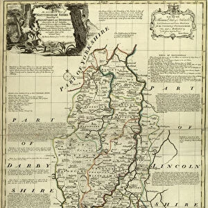
Framed Print : County Map of Nottinghamshire, c. 1777


![]()
Framed Photos from Sheffield City Archives
County Map of Nottinghamshire, c. 1777
From The Large English Atlas: or, a new set of map of all the counties of England and Wales drawn from the several surveys which have been hitherto been published. With three general maps of England, Scotland and Ireland, from the latest and best authorities, by Emanuel Bowen, Thomas Kitchin and others. London, printed and sold by T. Bowles, [c.1777]
Original at Sheffield Libraries: 912 STF
Sheffield City Archives and Local Studies Library has an unrivalled collection of images of Sheffield, England
Media ID 25501473
© Sheffield City Council - All Rights Reserved
Antique Map Bowens Map County Map Emanuel Bowen Old Map Thomas Kitchin Arnold Beeston Carlton Clifton Hucknall Mansfield Newark Nottingham Nottinghamshire Retford Worksop
14"x12" (38x32cm) Modern Frame
Discover the rich history of Nottinghamshire with our exquisite framed print from Media Storehouse. This beautiful reproduction showcases an original County Map of Nottinghamshire, dating back to 1777, taken from The Large English Atlas. Each detail of the intricately drawn map is brought to life, allowing you to explore the historical boundaries and landmarks of this fascinating county. Housed in a high-quality frame, this vintage map print makes a perfect addition to any home or office, adding character and charm to your decor while showcasing your love for history.
Wood effect frame, card mounted, 10x8 archival quality photo print. Overall outside dimensions 14x12 inches (38x32cm). Environmentally and ozone friendly, 40mm wide x 15mm Polycore® moulding has the look of real wood, is durable and light and easy to hang. Biodegradable and made with non-chlorinated gases (no toxic fumes) it is efficient; producing 100 tons of polystyrene can save 300 tons of trees! Prints are glazed with lightweight, shatterproof, optical clarity acrylic (providing the same general protection from the environment as glass). The back is stapled hardboard with a sawtooth hanger attached. Note: To minimise original artwork cropping, for optimum layout, and to ensure print is secure, the visible print may be marginally smaller
Contemporary Framed and Mounted Prints - Professionally Made and Ready to Hang
Estimated Image Size (if not cropped) is 18.8cm x 24.4cm (7.4" x 9.6")
Estimated Product Size is 32.5cm x 37.6cm (12.8" x 14.8")
These are individually made so all sizes are approximate
Artwork printed orientated as per the preview above, with portrait (vertical) orientation to match the source image.
FEATURES IN THESE COLLECTIONS
> Europe
> United Kingdom
> England
> Nottinghamshire
> Kirkby in Ashfield
> Europe
> United Kingdom
> England
> Nottinghamshire
> Sutton In Ashfield
> Sheffield City Archives
> Maps and Plans
> Bowen's County Maps, c. 1777
EDITORS COMMENTS
This antique map, titled "County Map of Nottinghamshire, c. 1777" takes us on a historical journey through the picturesque landscapes and charming towns of this English county. Crafted by renowned cartographers Emanuel Bowen and Thomas Kitchin, this map is a true testament to their expertise and attention to detail. The intricate lines and delicate shading bring to life the enchanting towns that dot Nottinghamshire's countryside. From the bustling city of Nottingham with its iconic castle, to the quaint market town of Mansfield nestled amidst rolling hills, every corner of this county is beautifully depicted. As we explore further, our eyes are drawn to notable landmarks such as Beeston Castle standing proudly atop a hill, or the elegant St Mary's Church in Carlton. The vibrant settlements of Sutton-in-Ashfield and West Bridgford also grace this map with their presence. Nottinghamshire's rich history unfolds before us as we discover Worksop's ancient priory ruins or Newark's imposing castle guarding over the River Trent. The smaller villages like Hucknall, Kirkby-in-Ashfield, Clifton, Retford, and Arnold add charm to an already captivating landscape. Preserved within Sheffield Libraries' archives for centuries, this print allows us a glimpse into England's past. It serves as a reminder of how much has changed yet how much remains unchanged in these timeless places
MADE IN THE UK
Safe Shipping with 30 Day Money Back Guarantee
FREE PERSONALISATION*
We are proud to offer a range of customisation features including Personalised Captions, Color Filters and Picture Zoom Tools
SECURE PAYMENTS
We happily accept a wide range of payment options so you can pay for the things you need in the way that is most convenient for you
* Options may vary by product and licensing agreement. Zoomed Pictures can be adjusted in the Basket.