Framed Print > Animals > Mammals > Delphinidae > Australis
Framed Print : 16th century world map


![]()
Framed Photos from Science Photo Library
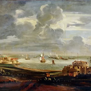
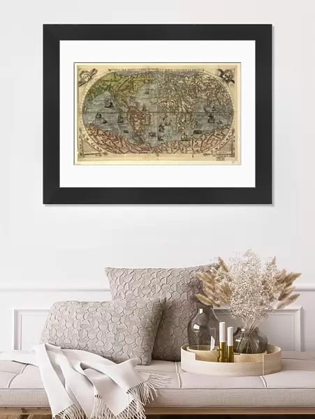
16th century world map
World map, published around 1565 in Venice, Italy, by Italian mapmaker Ferando Bertelli. The title of the map: Universale Descrittione di Tutta la Terra Conosciuta Fin Qui (universal description to the end of the known Earth). In the past few hundred years, the Americas (left) and the sea passage to India around Africa, and the islands of South-East Asia, had all been discovered, but these regions remained poorly mapped. This map shows a vast and unknown continent to the south, and Australia has not yet been discovered. Illustrations of ships and strange sea creatures are seen on the oceans, and strange animals are seen on the unknown lands. The winds are represented at upper right and left
Science Photo Library features Science and Medical images including photos and illustrations
Media ID 6349515
© LIBRARY OF CONGRESS, GEOGRAPHY AND MAP DIVISION/SCIENCE PHOTO LIBRARY
1500s 16th Century Africa America Ancient Cartography Continent Continents Diagram Eurasia Illustrated Inaccurate Incomplete Italian New World Old World Renaissance World 1565 Library Of Congress Terra Australis
22"x18" (58x48cm) Modern Frame
Discover the rich history of cartography with our exquisite selection of Framed Prints from Media Storehouse. This stunning piece showcases a rare 16th-century world map by Italian mapmaker Ferando Bertelli, published around 1565 in Venice, Italy. Known as "Universale Descrittione di Tutta la Terra Conosciuta Fin Qui," this captivating map provides a fascinating glimpse into the geographical knowledge of the time. Add an air of sophistication to your home or office with this beautiful, frameless addition to your decor. Delve into the past and embrace the wonders of exploration with our Framed Prints.
Wood effect frame, card mounted, 16x12 archival quality photo print. Overall outside dimensions 22x18 inches (58x48cm). Environmentally and ozone friendly, 40mm wide x 15mm Polycore® moulding has the look of real wood, is durable and light and easy to hang. Biodegradable and made with non-chlorinated gases (no toxic fumes) it is efficient; producing 100 tons of polystyrene can save 300 tons of trees! Prints are glazed with lightweight, shatterproof, optical clarity acrylic (providing the same general protection from the environment as glass). The back is stapled hardboard with a sawtooth hanger attached. Note: To minimise original artwork cropping, for optimum layout, and to ensure print is secure, the visible print may be marginally smaller
Contemporary Framed and Mounted Prints - Professionally Made and Ready to Hang
Estimated Image Size (if not cropped) is 39.6cm x 24.4cm (15.6" x 9.6")
Estimated Product Size is 57.9cm x 47.8cm (22.8" x 18.8")
These are individually made so all sizes are approximate
Artwork printed orientated as per the preview above, with landscape (horizontal) orientation to match the source image.
FEATURES IN THESE COLLECTIONS
> Africa
> Related Images
> Africa
> South Africa
> Maps
> Africa
> South Africa
> Related Images
> Animals
> Mammals
> Cricetidae
> Australis
> Animals
> Mammals
> Delphinidae
> Australis
> Animals
> Mammals
> Molossidae
> Australis
> Arts
> Art Movements
> Renaissance Art
> Arts
> Artists
> O
> Oceanic Oceanic
> Asia
> India
> Related Images
> Maps and Charts
> Popular Maps
EDITORS COMMENTS
This 16th-century world map, published in Venice by Italian mapmaker Ferando Bertelli around 1565, offers a fascinating glimpse into the state of geographical knowledge during the Renaissance era. Titled "Universale Descrittione di Tutta la Terra Conosciuta Fin Qui" (universal description to the end of the known Earth), it reflects an incomplete understanding of our planet's vastness and diversity. While regions such as Europe, Africa, and parts of Asia are relatively well-documented on this ancient artifact, significant gaps remain. The Americas appear on the left side but lack detailed mapping, while a mysterious southern continent looms large below. Notably absent is Australia, which had not yet been discovered at that time. The intricately illustrated oceans feature depictions of ships sailing through uncharted waters alongside fantastical sea creatures. On land, peculiar animals roam unfamiliar territories waiting to be explored and understood. Intriguingly, wind patterns are represented in the upper corners—a testament to early attempts at comprehending atmospheric dynamics. As we gaze upon this historical treasure from Science Photo Library's collection at the Library of Congress, we are reminded that human curiosity has always driven us to explore and unravel the mysteries surrounding our world. This remarkable piece serves as a reminder of how far we have come in charting our planet's geography since those times when maps were filled with both accuracy and imagination.
MADE IN THE UK
Safe Shipping with 30 Day Money Back Guarantee
FREE PERSONALISATION*
We are proud to offer a range of customisation features including Personalised Captions, Color Filters and Picture Zoom Tools
SECURE PAYMENTS
We happily accept a wide range of payment options so you can pay for the things you need in the way that is most convenient for you
* Options may vary by product and licensing agreement. Zoomed Pictures can be adjusted in the Basket.