Framed Print > Arts > Artists > A > Benedict Arnold
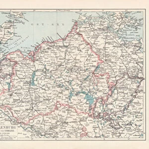
Framed Print : Maine map used in Arnolds invasion of Quebec, 1775


![]()
Framed Photos from North Wind
Maine map used in Arnolds invasion of Quebec, 1775
Montresors map of inland Maine, used for Arnolds march to Quebec, 1775.
Hand-colored woodcut of a 19th-century illustration
North Wind Picture Archives brings history to life with stock images and hand-colored illustrations
Media ID 5877051
© North Wind Picture Archives
1700s 1770s 1775 18th Century America American Revolution Army Arnold Artifact Attack Benedict Arnold Border Canada Canadian Continental Army Document French Canada Frontier Invade Invasion Maine Military New England Quebec Revolutionary War Route Wilderness Chaudiere River General Arnold Kennebec River Montresor
14"x12" (38x32cm) Modern Frame
Step back in time with our exclusive Framed Print from Media Storehouse, featuring a captivating image of Montresor's map used during Arnold's Invasion of Quebec in 1775. This intricately hand-colored woodcut, sourced from North Wind Picture Archives, showcases the detailed terrain of inland Maine that guided Arnold's troops during their historic campaign. Bring a piece of American history into your home or office with this beautifully framed and authentically aged print.
Wood effect frame, card mounted, 10x8 archival quality photo print. Overall outside dimensions 14x12 inches (38x32cm). Environmentally and ozone friendly, 40mm wide x 15mm Polycore® moulding has the look of real wood, is durable and light and easy to hang. Biodegradable and made with non-chlorinated gases (no toxic fumes) it is efficient; producing 100 tons of polystyrene can save 300 tons of trees! Prints are glazed with lightweight, shatterproof, optical clarity acrylic (providing the same general protection from the environment as glass). The back is stapled hardboard with a sawtooth hanger attached. Note: To minimise original artwork cropping, for optimum layout, and to ensure print is secure, the visible print may be marginally smaller
Contemporary Framed and Mounted Prints - Professionally Made and Ready to Hang
Estimated Image Size (if not cropped) is 17.8cm x 24.4cm (7" x 9.6")
Estimated Product Size is 32.5cm x 37.6cm (12.8" x 14.8")
These are individually made so all sizes are approximate
Artwork printed orientated as per the preview above, with portrait (vertical) orientation to match the source image.
FEATURES IN THESE COLLECTIONS
> Arts
> Artists
> A
> Benedict Arnold
> Arts
> Landscape paintings
> Waterfall and river artworks
> River artworks
> Europe
> France
> Canton
> Maine
> Europe
> United Kingdom
> England
> Maps
> Europe
> United Kingdom
> England
> Rivers
> Historic
> Ancient artifacts and relics
> North Wind Picture Archives
> American Revolution
> North Wind Picture Archives
> Maps
EDITORS COMMENTS
This print showcases a significant artifact from American history - the Maine map used in Arnold's invasion of Quebec in 1775. The hand-colored woodcut, based on a 19th-century illustration, transports us back to the tumultuous times of the Revolutionary War. The image depicts an intricate map that played a crucial role in General Benedict Arnold's audacious march towards Quebec. As we gaze upon this vintage document, we can almost envision the arduous route taken by the American army through Canada's wilderness and frontier regions. This historic piece serves as a testament to America's relentless pursuit of freedom and its determination to secure independence from British rule. It symbolizes not only our nation's military heritage but also represents the bravery and sacrifice exhibited by those who fought for liberty during this pivotal period. The Montresor map offers insight into the strategic planning undertaken by General Arnold as he navigated through treacherous terrains such as the Kennebec River and Chaudiere River. Its detailed illustrations provide historians with invaluable information about this daring expedition. As we admire this remarkable artwork, let us reflect on how it encapsulates an important chapter in North American history - one that shaped both Canada and the United States. This print stands as a reminder of our shared past and highlights the enduring legacy left behind by individuals like Benedict Arnold, whose actions forever altered the course of our continent's future.
MADE IN THE UK
Safe Shipping with 30 Day Money Back Guarantee
FREE PERSONALISATION*
We are proud to offer a range of customisation features including Personalised Captions, Color Filters and Picture Zoom Tools
SECURE PAYMENTS
We happily accept a wide range of payment options so you can pay for the things you need in the way that is most convenient for you
* Options may vary by product and licensing agreement. Zoomed Pictures can be adjusted in the Basket.