Framed Print > Europe > United Kingdom > England > Maps
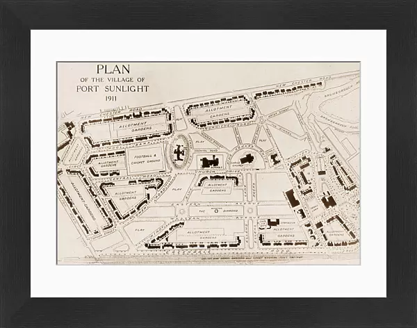
Framed Print : Port Sunlight Village map in 1911


![]()
Framed Photos from Mary Evans Picture Library
Port Sunlight Village map in 1911
Mary Evans Picture Library makes available wonderful images created for people to enjoy over the centuries
Media ID 32380112
© The Keasbury-Gordon Photograph Archive / Mary Evans
Bros Brothers Factories Lever Manufacture Manufacturing Soap Sunlight Wirral
22"x18" (58x48cm) Modern Frame
Step back in time with our stunning Framed Print from Media Storehouse, featuring the Port Sunlight Village map from 1911. This captivating image, sourced from The Keasbury-Gordon Photograph Archive Collection at Mary Evans Prints Online, offers a fascinating glimpse into the past. The intricate details of the map reveal the layout of the village as it once was, making it an essential addition to any home or office. With our high-quality framing options, this print is not only a beautiful piece of historical art but also a conversation starter. Bring a touch of history into your space and order yours today.
Wood effect frame, card mounted, 16x12 archival quality photo print. Overall outside dimensions 22x18 inches (58x48cm). Environmentally and ozone friendly, 40mm wide x 15mm Polycore® moulding has the look of real wood, is durable and light and easy to hang. Biodegradable and made with non-chlorinated gases (no toxic fumes) it is efficient; producing 100 tons of polystyrene can save 300 tons of trees! Prints are glazed with lightweight, shatterproof, optical clarity acrylic (providing the same general protection from the environment as glass). The back is stapled hardboard with a sawtooth hanger attached. Note: To minimise original artwork cropping, for optimum layout, and to ensure print is secure, the visible print may be marginally smaller
Contemporary Framed and Mounted Prints - Professionally Made and Ready to Hang
Estimated Image Size (if not cropped) is 39.6cm x 26.6cm (15.6" x 10.5")
Estimated Product Size is 57.9cm x 47.8cm (22.8" x 18.8")
These are individually made so all sizes are approximate
Artwork printed orientated as per the preview above, with landscape (horizontal) orientation to match the source image.
FEATURES IN THESE COLLECTIONS
> Europe
> United Kingdom
> England
> Maps
> Europe
> United Kingdom
> England
> Posters
> Europe
> United Kingdom
> England
> Related Images
> Maps and Charts
> Early Maps
> Maps and Charts
> Related Images
> Mary Evans Prints Online
> New Images July 2023
EDITORS COMMENTS
Step back in time with this vintage map print of Port Sunlight Village from 1911, as featured in The Keasbury-Gordon Photograph Archive Collection from Mary Evans Prints Online. This intricately detailed lantern slide presents an Edwardian-era view of the picturesque Port Sunlight Village located on the Wirral Peninsula in England. Established by the Lever Brothers in 1888 as a model village for their soap factory workers, Port Sunlight was designed to provide a healthy and pleasant living environment. The map reveals the extensive network of streets and lanes that crisscrossed the village, with names such as Dock Road, Mill Lane, and Church Road, all neatly labeled. The Lever Brothers' factories, including the soap works and chemical works, dominate the northern part of the map, while the southern section is filled with residential areas, schools, churches, and community buildings. This early 20th-century map offers a fascinating glimpse into the industrial past of Port Sunlight Village. The Lever Brothers' commitment to providing their workers with decent housing, education, and recreational facilities was a pioneering approach to industrial welfare, making Port Sunlight a groundbreaking example of a model village. The intricate lines and meticulous detail in this map print evoke the Victorian and Edwardian eras, transporting us back to a time when industry and community were intricately intertwined. Hang this piece in your home or office to add a touch of history and charm to your space.
MADE IN THE UK
Safe Shipping with 30 Day Money Back Guarantee
FREE PERSONALISATION*
We are proud to offer a range of customisation features including Personalised Captions, Color Filters and Picture Zoom Tools
SECURE PAYMENTS
We happily accept a wide range of payment options so you can pay for the things you need in the way that is most convenient for you
* Options may vary by product and licensing agreement. Zoomed Pictures can be adjusted in the Basket.