Framed Print > Popular Themes > Railway Posters
Framed Print : Station map


![]()
Framed Photos from Mary Evans Picture Library
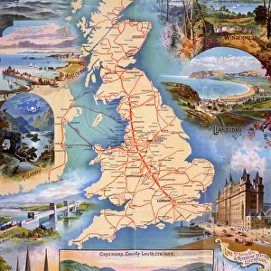
Station map
Z Macaulays station map of the railways in Great Britain, 1854 Date: 1854
Mary Evans Picture Library makes available wonderful images created for people to enjoy over the centuries
Media ID 7401943
© Mary Evans Picture Library 2015 - https://copyrighthub.org/s0/hub1/creation/maryevans/MaryEvansPictureID/10474746
22"x18" (58x48cm) Modern Frame
Discover the rich history of rail transportation in Great Britain with our exquisite framed print from Media Storehouse. This captivating station map, dated 1854, is a rare find from Z Macaulay's collection, available through Mary Evans Prints Online. With intricate details and meticulous accuracy, this vintage map showcases the extensive railway network in Great Britain during an era of significant growth and innovation. Add this unique piece to your home or office décor and transport yourself back in time. Each framed print is carefully crafted with museum-quality materials to ensure longevity and protection, making it a perfect addition to any space. Elevate your interior design and ignite conversations with this stunning, framed station map from Media Storehouse.
Wood effect frame, card mounted, 16x12 archival quality photo print. Overall outside dimensions 22x18 inches (58x48cm). Environmentally and ozone friendly, 40mm wide x 15mm Polycore® moulding has the look of real wood, is durable and light and easy to hang. Biodegradable and made with non-chlorinated gases (no toxic fumes) it is efficient; producing 100 tons of polystyrene can save 300 tons of trees! Prints are glazed with lightweight, shatterproof, optical clarity acrylic (providing the same general protection from the environment as glass). The back is stapled hardboard with a sawtooth hanger attached. Note: To minimise original artwork cropping, for optimum layout, and to ensure print is secure, the visible print may be marginally smaller
Contemporary Framed and Mounted Prints - Professionally Made and Ready to Hang
Estimated Image Size (if not cropped) is 26.9cm x 39.6cm (10.6" x 15.6")
Estimated Product Size is 47.8cm x 57.9cm (18.8" x 22.8")
These are individually made so all sizes are approximate
Artwork printed orientated as per the preview above, with portrait (vertical) orientation to match the source image.
FEATURES IN THESE COLLECTIONS
> Maps and Charts
> Related Images
> Popular Themes
> Railway Posters
> Mary Evans Prints Online
> National Archives
EDITORS COMMENTS
1. Title: "A Journey Through Time: Macaulay's 1854 Station Map of the Railways in Great Britain" This antique print, dated 1854, showcases the intricate and extensive railway network that crisscrossed Great Britain during the 19th century. The map, created by the renowned Scottish civil engineer and geographer, Charles T. R. Macaulay, offers a fascinating glimpse into the early days of the railway era. Macaulay's map, featuring 53 major stations, was a groundbreaking achievement in its time, as the railway system was rapidly expanding and connecting the vast and diverse regions of the British Isles. The intricate detailing of the map reveals the meticulous planning and engineering prowess required to construct and maintain the railway infrastructure. The map is adorned with various symbols and annotations, denoting the different railway companies, their lines, and the distances between stations. The intricate network of lines weaves through the landscape, connecting major cities and towns, and providing a means of transportation that revolutionized travel and commerce. The map's antique charm transports us back in time, allowing us to appreciate the ingenuity and ambition of the Victorian era. It serves as a testament to the transformative impact of the railway system on Great Britain, paving the way for the modern transportation infrastructure we know today. This print, sourced from Mary Evans Prints Online, is a valuable historical document that offers a unique perspective on the railway network during the 19th century. It is an essential addition to any collection focusing on transportation history, Victorian-era studies, or British cultural heritage. In conclusion, Macaulay's 1854 Station Map of the Railways in Great Britain is a captivating and historically significant piece that offers a glimpse into the past, showcasing the remarkable progress and innovation of the railway system during the Victorian era.
MADE IN THE UK
Safe Shipping with 30 Day Money Back Guarantee
FREE PERSONALISATION*
We are proud to offer a range of customisation features including Personalised Captions, Color Filters and Picture Zoom Tools
SECURE PAYMENTS
We happily accept a wide range of payment options so you can pay for the things you need in the way that is most convenient for you
* Options may vary by product and licensing agreement. Zoomed Pictures can be adjusted in the Basket.