Framed Print > Animals > Mammals > Muridae > Water Mouse
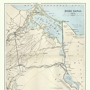
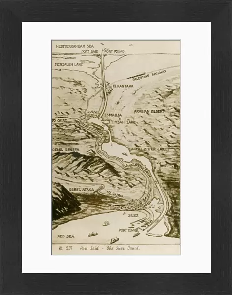
Framed Print : Map of the Suez Canal, Egypt


![]()
Framed Photos from Mary Evans Picture Library
Map of the Suez Canal, Egypt
Map of the Suez Canal in Egypt showing the water way from the Mediterranean Sea to the Red Sea which was constructed in the 19th century by the Suez Canal Company founded by Ferdinand de Lesseps. The map also illustrates most of the major travel routes in the area. Date: circa 1930
Mary Evans Picture Library makes available wonderful images created for people to enjoy over the centuries
Media ID 14403081
© Mary Evans / Pharcide
Area Canal Canals Ismailia Lakes Maps Mediterranean Route Routes Seas Suez Tewfik Track Tracks Travelling Ways
22"x18" (58x48cm) Modern Frame
Discover the rich history of maritime navigation with our stunning Framed Print of the Map of the Suez Canal, Egypt. This exquisite piece, sourced from Mary Evans Prints Online, showcases the engineering marvel constructed in the 19th century by the Suez Canal Company under the leadership of Ferdinand de Lesseps. The intricate details of the map reveal the waterway that connects the Mediterranean Sea to the Red Sea, providing a captivating glimpse into the past. Bring a touch of history and sophistication to your home or office with this beautiful framed print.
Wood effect frame, card mounted, 16x12 archival quality photo print. Overall outside dimensions 22x18 inches (58x48cm). Environmentally and ozone friendly, 40mm wide x 15mm Polycore® moulding has the look of real wood, is durable and light and easy to hang. Biodegradable and made with non-chlorinated gases (no toxic fumes) it is efficient; producing 100 tons of polystyrene can save 300 tons of trees! Prints are glazed with lightweight, shatterproof, optical clarity acrylic (providing the same general protection from the environment as glass). The back is stapled hardboard with a sawtooth hanger attached. Note: To minimise original artwork cropping, for optimum layout, and to ensure print is secure, the visible print may be marginally smaller
Contemporary Framed and Mounted Prints - Professionally Made and Ready to Hang
Estimated Image Size (if not cropped) is 23.9cm x 39.6cm (9.4" x 15.6")
Estimated Product Size is 47.8cm x 57.9cm (18.8" x 22.8")
These are individually made so all sizes are approximate
Artwork printed orientated as per the preview above, with portrait (vertical) orientation to match the source image.
FEATURES IN THESE COLLECTIONS
> Africa
> Egypt
> Lakes
> Related Images
> Africa
> Egypt
> Related Images
> Animals
> Mammals
> Muridae
> Water Mouse
> Maps and Charts
> Related Images
> Popular Themes
> Railway Posters
EDITORS COMMENTS
This map print from circa 1930 showcases the Suez Canal in Egypt, an engineering marvel of the 19th century. The waterway stretches from the Mediterranean Sea to the Red Sea, connecting two major bodies of water and significantly reducing the distance and time required for international maritime travel between Europe and Asia. The intricately detailed map illustrates the Suez Canal's winding path, as it cuts through the Egyptian desert, passing by the cities of Ismailia and Port Said in the eastern and western terminals, respectively. The map also highlights the major travel routes in the area, including the railway tracks that run parallel to the canal, providing an alternative means of transportation for both people and goods. The map reveals several lakes and bodies of water in the region, such as the Bitter Lakes and the Lake Timsah, which were used as part of the canal's lock system to help regulate the water levels and facilitate the passage of ships. The map also marks various ports and anchorages along the canal, providing essential information for travelers and sailors of the time. Ferdinand de Lesseps, a French diplomat and entrepreneur, founded the Suez Canal Company in 1858, with the vision of constructing the canal to facilitate global trade and travel. The map serves as a testament to the ingenuity and ambition of the time, offering a glimpse into the rich history of maritime exploration and the development of international travel routes.
MADE IN THE UK
Safe Shipping with 30 Day Money Back Guarantee
FREE PERSONALISATION*
We are proud to offer a range of customisation features including Personalised Captions, Color Filters and Picture Zoom Tools
SECURE PAYMENTS
We happily accept a wide range of payment options so you can pay for the things you need in the way that is most convenient for you
* Options may vary by product and licensing agreement. Zoomed Pictures can be adjusted in the Basket.