Framed Print > Europe > Iceland > Maps
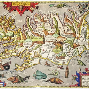
Framed Print : Map / Europe / Iceland 18C


![]()
Framed Photos from Mary Evans Picture Library
Map / Europe / Iceland 18C
Date: early 18th century
Mary Evans Picture Library makes available wonderful images created for people to enjoy over the centuries
Media ID 571502
© Mary Evans Picture Library 2015 - https://copyrighthub.org/s0/hub1/creation/maryevans/MaryEvansPictureID/10003760
14"x12" (38x32cm) Modern Frame
Introducing the exquisite "Map / Europe / Iceland 18C" print from the Media Storehouse Framed Prints collection, brought to you by Mary Evans Picture Library. This stunning early 18th century map offers a captivating glimpse into the cartography of yesteryears. The intricate detailing and vibrant colors beautifully depict Europe with a special focus on Iceland. Each print is carefully framed with a contemporary design, making it a perfect addition to your home or office decor. Transport yourself back in time and explore the rich history of cartography with this elegant and timeless piece.
Wood effect frame, card mounted, 10x8 archival quality photo print. Overall outside dimensions 14x12 inches (38x32cm). Environmentally and ozone friendly, 40mm wide x 15mm Polycore® moulding has the look of real wood, is durable and light and easy to hang. Biodegradable and made with non-chlorinated gases (no toxic fumes) it is efficient; producing 100 tons of polystyrene can save 300 tons of trees! Prints are glazed with lightweight, shatterproof, optical clarity acrylic (providing the same general protection from the environment as glass). The back is stapled hardboard with a sawtooth hanger attached. Note: To minimise original artwork cropping, for optimum layout, and to ensure print is secure, the visible print may be marginally smaller
Contemporary Framed and Mounted Prints - Professionally Made and Ready to Hang
Estimated Image Size (if not cropped) is 24.4cm x 17.8cm (9.6" x 7")
Estimated Product Size is 37.6cm x 32.5cm (14.8" x 12.8")
These are individually made so all sizes are approximate
Artwork printed orientated as per the preview above, with landscape (horizontal) orientation to match the source image.
FEATURES IN THESE COLLECTIONS
> Europe
> Iceland
> Related Images
> Europe
> Related Images
> Maps and Charts
> Early Maps
> Maps and Charts
> Related Images
EDITORS COMMENTS
This print of a historical map of Europe, specifically focusing on Iceland in the early 18th century, offers a fascinating glimpse into the past. The intricate details and delicate craftsmanship of this map showcase the cartographer's skill and dedication to accurately representing the geography of this region during that time period.
As we study this map, we are transported back to a time when exploration and discovery were at the forefront of society. The names of towns, rivers, and mountains are carefully labeled, providing valuable insight into how people navigated and understood their world centuries ago.
Iceland, with its rugged terrain and unique cultural heritage, is prominently featured on this map, reminding us of its importance in European history. From Reykjavik to Akureyri, each place is meticulously depicted with precision and care.
This print from Mary Evans Picture Library serves as a reminder of the rich history that has shaped our world today. It invites us to explore the past through cartography and appreciate the artistry involved in creating such detailed maps. Whether you are a history buff or simply intrigued by old-world charm, this map is sure to captivate your imagination and inspire further exploration into Europe's fascinating past.
MADE IN THE UK
Safe Shipping with 30 Day Money Back Guarantee
FREE PERSONALISATION*
We are proud to offer a range of customisation features including Personalised Captions, Color Filters and Picture Zoom Tools
SECURE PAYMENTS
We happily accept a wide range of payment options so you can pay for the things you need in the way that is most convenient for you
* Options may vary by product and licensing agreement. Zoomed Pictures can be adjusted in the Basket.