Framed Print : Map of Egypt


![]()
Framed Photos from Mary Evans Picture Library
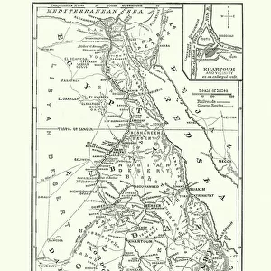
Map of Egypt
Map of Egypt.
1841
Mary Evans Picture Library makes available wonderful images created for people to enjoy over the centuries
Media ID 14416477
© Mary Evans Picture Library
14"x12" (38x32cm) Modern Frame
Wood effect frame, card mounted, 10x8 archival quality photo print. Overall outside dimensions 14x12 inches (38x32cm). Environmentally and ozone friendly, 40mm wide x 15mm Polycore® moulding has the look of real wood, is durable and light and easy to hang. Biodegradable and made with non-chlorinated gases (no toxic fumes) it is efficient; producing 100 tons of polystyrene can save 300 tons of trees! Prints are glazed with lightweight, shatterproof, optical clarity acrylic (providing the same general protection from the environment as glass). The back is stapled hardboard with a sawtooth hanger attached. Note: To minimise original artwork cropping, for optimum layout, and to ensure print is secure, the visible print may be marginally smaller
Contemporary Framed and Mounted Prints - Professionally Made and Ready to Hang
Estimated Image Size (if not cropped) is 18.8cm x 24.4cm (7.4" x 9.6")
Estimated Product Size is 32.5cm x 37.6cm (12.8" x 14.8")
These are individually made so all sizes are approximate
Artwork printed orientated as per the preview above, with portrait (vertical) orientation to match the source image.
EDITORS COMMENTS
This stunning antique map print, titled 'Map of Egypt,' dates back to the year 1841, making it an intriguing relic of the 1840s. The map provides a detailed and captivating representation of Egypt during the early Victorian era, showcasing the intricacies of the Middle East and North African country during a time of significant exploration and discovery. The map is centered around the Nile River, the lifeblood of ancient Egypt, and its delta, which is depicted with remarkable detail. The winding river, marked with various towns and cities, leads to the Mediterranean Sea in the north and the Red Sea in the east. The Suez Canal, which would not be constructed until 1869, is not yet visible on this map, adding to its historical significance. The map also includes various topographical features, such as mountains, deserts, and oases, as well as major bodies of water, including the Mediterranean Sea, the Red Sea, and the Gulf of Suez. The map's rich detail and accuracy reflect the advancements in cartography during the 19th century, as explorers and surveyors sought to better understand the world around them. The map is a testament to the fascination that Egypt held for Europeans during the Victorian era, as the discoveries of ancient Egyptian civilization continued to captivate the imaginations of scholars, adventurers, and travelers alike. This beautiful and historic map print is a must-have for anyone interested in Egypt, cartography, or the history of exploration.
MADE IN THE UK
Safe Shipping with 30 Day Money Back Guarantee
FREE PERSONALISATION*
We are proud to offer a range of customisation features including Personalised Captions, Color Filters and Picture Zoom Tools
SECURE PAYMENTS
We happily accept a wide range of payment options so you can pay for the things you need in the way that is most convenient for you
* Options may vary by product and licensing agreement. Zoomed Pictures can be adjusted in the Basket.