Framed Print > Maps and Charts > Early Maps
Framed Print : Map / Asia / Mongol Empire


![]()
Framed Photos from Mary Evans Picture Library
Map / Asia / Mongol Empire
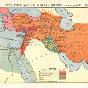
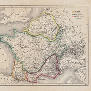
The Mongol Empire at its greatest extent : commenced by Genghis Khan in the 13th century, it was enlarged by Kublai Khan but broke up after about 1380
Mary Evans Picture Library makes available wonderful images created for people to enjoy over the centuries
Media ID 584825
© Mary Evans Picture Library 2015 - https://copyrighthub.org/s0/hub1/creation/maryevans/MaryEvansPictureID/10038070
1300 1380 13th Broke Commenced Enlarged Extent Genghis Greatest Khan Kublai Maps Mongol
14"x12" (38x32cm) Modern Frame
Introducing the captivating "Map / Asia / Mongol Empire" print from the Media Storehouse collection, brought to you by Mary Evans Picture Library via Mary Evans Prints Online. This exquisite framed print showcases an intricately detailed map depicting the vast Mongol Empire at its peak, ruled by the legendary leaders Genghis Khan and Kublai Khan in the 13th and 14th centuries. Explore the rich history and grandeur of this powerful dynasty as you adorn your walls with this captivating and historically significant piece. Perfect for history enthusiasts, world travelers, or anyone seeking to add a touch of culture and sophistication to their space. Bring the past to life with the "Map / Asia / Mongol Empire" print from Media Storehouse.
Wood effect frame, card mounted, 10x8 archival quality photo print. Overall outside dimensions 14x12 inches (38x32cm). Environmentally and ozone friendly, 40mm wide x 15mm Polycore® moulding has the look of real wood, is durable and light and easy to hang. Biodegradable and made with non-chlorinated gases (no toxic fumes) it is efficient; producing 100 tons of polystyrene can save 300 tons of trees! Prints are glazed with lightweight, shatterproof, optical clarity acrylic (providing the same general protection from the environment as glass). The back is stapled hardboard with a sawtooth hanger attached. Note: To minimise original artwork cropping, for optimum layout, and to ensure print is secure, the visible print may be marginally smaller
Contemporary Framed and Mounted Prints - Professionally Made and Ready to Hang
Estimated Image Size (if not cropped) is 24.4cm x 17.9cm (9.6" x 7")
Estimated Product Size is 37.6cm x 32.5cm (14.8" x 12.8")
These are individually made so all sizes are approximate
Artwork printed orientated as per the preview above, with landscape (horizontal) orientation to match the source image.
FEATURES IN THESE COLLECTIONS
> Asia
> Related Images
> Maps and Charts
> Early Maps
> Maps and Charts
> Related Images
> Popular Themes
> Maps and Charts
EDITORS COMMENTS
This map print showcases the Mongol Empire at its greatest extent during the 13th century, a historical period marked by the remarkable reigns of Genghis Khan and Kublai Khan. The Mongol Empire, which commenced under Genghis Khan in the early 13th century, was initially a small nomadic confederation in the Mongolian plateau. However, under Genghis Khan's leadership, it grew into a formidable military power that conquered vast territories in Asia and Eastern Europe. Genghis Khan's successor, Ögödei Khan, continued the empire's expansion, and it was further enlarged under Kublai Khan in the late 13th century. At its peak, the Mongol Empire stretched from the Pacific Ocean in the east to the Caspian Sea in the west, and from the Arctic Ocean in the north to the Indian subcontinent in the south. The Mongol Empire's cultural and economic influence extended far beyond its borders, and it facilitated the exchange of goods, ideas, and technologies between different civilizations. The map illustrates the empire's territorial reach, with various regions labeled, including China, Persia, India, Russia, and the Middle East. This map is an invaluable historical resource, providing a visual representation of the Mongol Empire's vast territorial extent during the 13th century. It serves as a reminder of the empire's significant impact on world history and its lasting legacy. The intricate details and vibrant colors bring the map to life, making it an essential addition to any history or geography collection.
MADE IN THE UK
Safe Shipping with 30 Day Money Back Guarantee
FREE PERSONALISATION*
We are proud to offer a range of customisation features including Personalised Captions, Color Filters and Picture Zoom Tools
SECURE PAYMENTS
We happily accept a wide range of payment options so you can pay for the things you need in the way that is most convenient for you
* Options may vary by product and licensing agreement. Zoomed Pictures can be adjusted in the Basket.