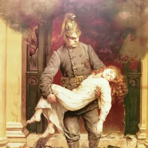
Framed Print > Europe > United Kingdom > England > London > Fire Brigade
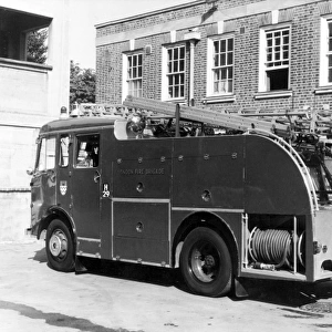
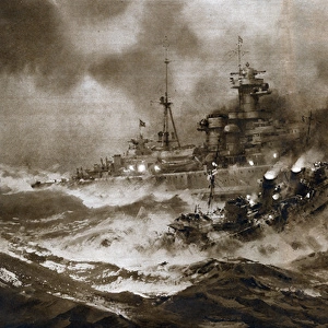
Framed Print : Area map for the National Fire Service in London, WW2


Resolution may be poor at this size (102 DPI)
![]()
Framed Photos from Mary Evans Picture Library
Area map for the National Fire Service in London, WW2
Area map for the National Fire Service in London
Mary Evans Picture Library makes available wonderful images created for people to enjoy over the centuries
Media ID 7638303
© London Fire Brigade / Mary Evans Picture Library
1941 Area Areas Districts Divided Greater Maps Regions Sections Services Firefighter Firefighting
30"x26" (78x68cm) Modern Frame
Discover the historical significance of the National Fire Service in London during World War II with our stunning framed print from the London Fire Brigade and Mary Evans Picture Library. This exclusive piece showcases an area map that offers a fascinating insight into the vital role the National Fire Service played in protecting the city during this pivotal time in history. With intricate detail and authenticity, this framed print is not only an attractive addition to your home or office but also a conversation starter and a reminder of the bravery and resilience of the firefighters who served during the war. Bring a piece of history into your space with our high-quality framed print from the Media Storehouse range.
Wood effect frame, card mounted, 24x20 archival quality photo print. Overall outside dimensions 30x26 inches (76x68cm). Environmentally and ozone friendly, 43mm wide x 32mm Polycore® moulding has the look of real wood, is durable and light and easy to hang. Biodegradable and made with non-chlorinated gases (no toxic fumes) it is efficient; producing 100 tons of polystyrene can save 300 tons of trees! Prints are glazed with lightweight, shatterproof, optical clarity acrylic (providing the same general protection from the environment as glass). The back is stapled hardboard with a sawtooth hanger attached. Note: To minimise original artwork cropping, for optimum layout, and to ensure print is secure, the visible print may be marginally smaller
Contemporary Framed and Mounted Prints - Professionally Made and Ready to Hang
Estimated Image Size (if not cropped) is 59.9cm x 57.9cm (23.6" x 22.8")
Estimated Product Size is 78.2cm x 68.2cm (30.8" x 26.9")
These are individually made so all sizes are approximate
Artwork printed orientated as per the preview above, with landscape (horizontal) orientation to match the source image.
FEATURES IN THESE COLLECTIONS
> Animals
> Mammals
> Muridae
> Fortior
> Europe
> United Kingdom
> England
> Greater London
> Related Images
> Europe
> United Kingdom
> England
> London
> Fire Brigade
> Historic
> World War I and II
> World War II
> Maps and Charts
> Related Images
> Maps and Charts
> World
> Popular Themes
> Firefighters
> Mary Evans Prints Online
> London Fire Brigade
EDITORS COMMENTS
This historic area map for the National Fire Service in London, dating back to the 1940s during World War II, provides a fascinating insight into the organizational structure of firefighting services in the British capital during a time of great adversity. The map is divided into greater regions, districts, and sections, each with its own unique identifier, reflecting the extensive coverage and comprehensive response capabilities of the National Fire Service. The map serves as a testament to the importance of effective communication and coordination during wartime, with clear markings indicating fire stations, fire brigades, and other key facilities such as water towers and air raid shelters. The intricate detailing of the map underscores the meticulous planning and preparation that went into ensuring the safety and security of London's residents during the war. The National Fire Service played a crucial role in protecting London from the devastating effects of the Blitz, with firefighters working tirelessly to extinguish fires caused by German air raids. This map would have been an essential tool for firefighters and commanders, enabling them to quickly and efficiently deploy resources to areas in need. The map also highlights the extensive network of fire stations and brigades that were established across London during this period, with each station identified by its unique number and location. The map's intricate detailing and clear, easy-to-read design make it an invaluable resource for anyone interested in the history of firefighting in London during World War II. This photograph is from the London Fire Brigade collection at Mary Evans Picture Library and provides a unique glimpse into the past, offering a valuable insight into the logistical challenges and operational strategies of firefighting services during wartime.
MADE IN THE UK
Safe Shipping with 30 Day Money Back Guarantee
FREE PERSONALISATION*
We are proud to offer a range of customisation features including Personalised Captions, Color Filters and Picture Zoom Tools
SECURE PAYMENTS
We happily accept a wide range of payment options so you can pay for the things you need in the way that is most convenient for you
* Options may vary by product and licensing agreement. Zoomed Pictures can be adjusted in the Basket.