Framed Print > Arts > Photorealistic artworks > Detailed art pieces > Masterful detailing in art
Framed Print : Old Map of Spain and Portugal 1852 by Henry George Collins


![]()
Framed Photos from MapSeeker
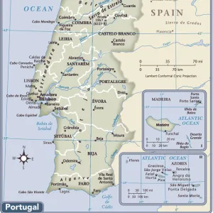
Old Map of Spain and Portugal 1852 by Henry George Collins
This is a finely detailed map of Spain and Portugal remastered from a rare Atlas of the World published in 1852 by Henry George Collins. Although these Henry Collins produced maps of the highest quality in his time unfortunately not the same could be said in terms of his business success. His maps were later obtained by the famous Stanford Map Company and used in their publications
Welcome to the Mapseeker Image library and enter an historic gateway to one of the largest on-line collections of Historic Maps, Nostalgic Views, Vista's and Panorama's from a World gone by.
Media ID 20347420
© Mapseeker Publishing Ltd
Collins Collins Atlas Collins Atlas Map Collins Map
22"x18" (58x48cm) Modern Frame
Discover history with our exquisitely detailed Framed Print of the Old Map of Spain and Portugal by Henry George Collins. This stunning piece, remastered from the rare Atlas of the World published in 1852, showcases the intricate cartography work of renowned mapmaker Henry George Collins. Transport yourself back in time as you explore the borders and territories of Spain and Portugal as they were depicted over 160 years ago. Each print is carefully framed to preserve and enhance its rich details, making it a captivating addition to any home or office space.
Wood effect frame, card mounted, 16x12 archival quality photo print. Overall outside dimensions 22x18 inches (58x48cm). Environmentally and ozone friendly, 40mm wide x 15mm Polycore® moulding has the look of real wood, is durable and light and easy to hang. Biodegradable and made with non-chlorinated gases (no toxic fumes) it is efficient; producing 100 tons of polystyrene can save 300 tons of trees! Prints are glazed with lightweight, shatterproof, optical clarity acrylic (providing the same general protection from the environment as glass). The back is stapled hardboard with a sawtooth hanger attached. Note: To minimise original artwork cropping, for optimum layout, and to ensure print is secure, the visible print may be marginally smaller
Contemporary Framed and Mounted Prints - Professionally Made and Ready to Hang
Estimated Image Size (if not cropped) is 39.6cm x 26.4cm (15.6" x 10.4")
Estimated Product Size is 57.9cm x 47.8cm (22.8" x 18.8")
These are individually made so all sizes are approximate
Artwork printed orientated as per the preview above, with landscape (horizontal) orientation to match the source image.
FEATURES IN THESE COLLECTIONS
> Arts
> Photorealistic artworks
> Detailed art pieces
> Masterful detailing in art
> Europe
> Portugal
> Related Images
> Maps and Charts
> Related Images
> Maps and Charts
> Spain
> Maps and Charts
> World
EDITORS COMMENTS
This beautifully preserved print showcases an exquisite "Old Map of Spain and Portugal" from the year 1852, meticulously crafted by the talented cartographer Henry George Collins. Remastered from a rare Atlas of the World published during that era, this map offers a fascinating glimpse into the geographical landscape of these Iberian nations in times long past. Henry Collins was renowned for his exceptional craftsmanship, producing maps of unparalleled quality during his time. However, despite his remarkable talent, he faced challenges in terms of business success. Fortunately, his invaluable maps found their way into the hands of the esteemed Stanford Map Company, who recognized their significance and incorporated them into their own publications. The level of detail captured within this map is truly awe-inspiring. Every contour line and geographic feature has been intricately rendered to provide an accurate representation of Spain and Portugal as they were over 150 years ago. From major cities to rivers and mountain ranges, this historic document allows us to trace the footsteps of our ancestors through these enchanting lands. Whether you are a history enthusiast or simply captivated by vintage cartography, this "Old Map of Spain and Portugal" is sure to transport you back in time. It serves as a testament to both Henry George Collins' artistic prowess and the enduring allure held by these captivating regions on Europe's southwestern coast.
MADE IN THE UK
Safe Shipping with 30 Day Money Back Guarantee
FREE PERSONALISATION*
We are proud to offer a range of customisation features including Personalised Captions, Color Filters and Picture Zoom Tools
SECURE PAYMENTS
We happily accept a wide range of payment options so you can pay for the things you need in the way that is most convenient for you
* Options may vary by product and licensing agreement. Zoomed Pictures can be adjusted in the Basket.