Framed Print > Arts > Artists > H > Jodocus Hondius
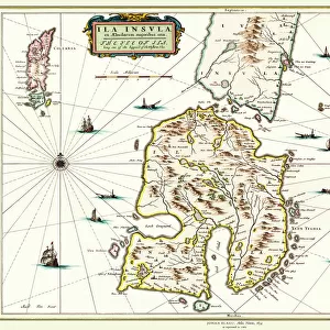
Framed Print : Old Map of England 1635 by Willem & Johan Blaeu from the Theatrum Orbis Terrarum


![]()
Framed Photos from MapSeeker
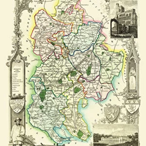
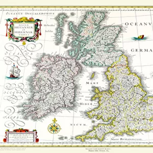
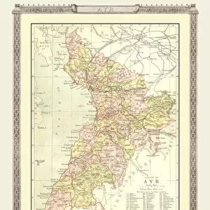
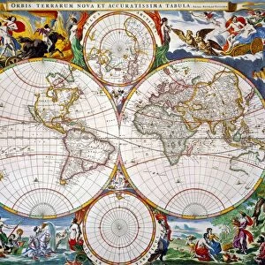
Old Map of England 1635 by Willem & Johan Blaeu from the Theatrum Orbis Terrarum
This detailed and most attractive reproduction map of England has been carefully art worked from a scan of an antique original. The famous firm of Dutch cartographers and publishers was established in the late 16th century by Willem Janszoon Blaeu in Amsterdam. Blaeu was a maker of globes and scientific instruments and purchased some of his early map plates from Jodocus Hondius. From this small beginning was to emerge one of the largest and most prolific map publishing houses of the seventeenth century
Welcome to the Mapseeker Image library and enter an historic gateway to one of the largest on-line collections of Historic Maps, Nostalgic Views, Vista's and Panorama's from a World gone by.
Media ID 20348015
Blaeu Blaeu Family Blaue Map Historic Map Johan Blaeu Johan Blaeu Map Old Blaue Map
22"x18" (58x48cm) Modern Frame
Discover history with our exquisite Framed Print of Old Map of England 1635 by Willem & Johan Blaeu from Theatrum Orbis Terrarum. Each print is meticulously crafted from a high-resolution scan of an original antique map, bringing the intricate details and rich history of this precious artifact to life. The intriguing depiction of England in 1635, as captured in this detailed reproduction, makes for a captivating addition to any home or office. Experience the allure of cartography and add a touch of history to your space with our Framed Print of Old Map of England 1635 by Willem & Johan Blaeu.
Wood effect frame, card mounted, 16x12 archival quality photo print. Overall outside dimensions 22x18 inches (58x48cm). Environmentally and ozone friendly, 40mm wide x 15mm Polycore® moulding has the look of real wood, is durable and light and easy to hang. Biodegradable and made with non-chlorinated gases (no toxic fumes) it is efficient; producing 100 tons of polystyrene can save 300 tons of trees! Prints are glazed with lightweight, shatterproof, optical clarity acrylic (providing the same general protection from the environment as glass). The back is stapled hardboard with a sawtooth hanger attached. Note: To minimise original artwork cropping, for optimum layout, and to ensure print is secure, the visible print may be marginally smaller
Contemporary Framed and Mounted Prints - Professionally Made and Ready to Hang
Estimated Image Size (if not cropped) is 39.6cm x 26.4cm (15.6" x 10.4")
Estimated Product Size is 57.9cm x 47.8cm (22.8" x 18.8")
These are individually made so all sizes are approximate
Artwork printed orientated as per the preview above, with landscape (horizontal) orientation to match the source image.
FEATURES IN THESE COLLECTIONS
> Arts
> Artists
> B
> Willem Blaeu
> Arts
> Artists
> H
> Jodocus Hondius
> Arts
> Photorealistic artworks
> Detailed art pieces
> Masterful detailing in art
> Europe
> United Kingdom
> England
> Maps
> Maps and Charts
> Early Maps
> Maps and Charts
> Related Images
> Maps and Charts
> Willem Janszoon Blaeu
> MapSeeker
> Maps from the British Isles
> England with Wales PORTFOLIO
EDITORS COMMENTS
This exquisite print showcases the "Old Map of England 1635" by Willem and Johan Blaeu, sourced from the renowned Theatrum Orbis Terrarum. Meticulously crafted from a scan of an antique original, this reproduction map offers a captivating glimpse into England's rich historical past. The Blaeu family, hailing from Amsterdam, established their esteemed cartography and publishing firm in the late 16th century. Willem Janszoon Blaeu himself was not only a skilled maker of globes and scientific instruments but also acquired some map plates from Jodocus Hondius during his early years. Little did he know that this humble beginning would pave the way for one of the most prolific map publishing houses of the seventeenth century. With intricate details and artistic finesse, this historic map transports us back to 1635 when England was undergoing significant transformations. From its majestic coastlines to its sprawling landscapes, every contour has been faithfully reproduced to offer an authentic experience. Whether you are an avid history enthusiast or simply appreciate fine artistry, this old English map is sure to captivate your imagination. Let it serve as a window into a bygone era where exploration and discovery were at their peak
MADE IN THE UK
Safe Shipping with 30 Day Money Back Guarantee
FREE PERSONALISATION*
We are proud to offer a range of customisation features including Personalised Captions, Color Filters and Picture Zoom Tools
SECURE PAYMENTS
We happily accept a wide range of payment options so you can pay for the things you need in the way that is most convenient for you
* Options may vary by product and licensing agreement. Zoomed Pictures can be adjusted in the Basket.