Framed Print > Liszt Collection > Engravings > France
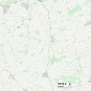
Framed Print : Map of Ille Et Vilaine, France


![]()
Framed Photos from Liszt Collection
Map of Ille Et Vilaine, France
Liszt Collection of nineteenth-century engravings and images to browse and enjoy
Media ID 12974853
© Quint Lox Limited
14"x12" (38x32cm) Modern Frame
Discover the beauty of Ille Et Vilaine, France, with our exquisite Framed Print from the Liszt Collection. This stunning map, titled "Map of Ille Et Vilaine, France" by 000030, adds a touch of sophistication and worldly charm to any space. The high-quality print is expertly framed in a sleek and modern design, ensuring your new addition is both visually appealing and durable. Bring a piece of France into your home or office with our Framed Print of the Map of Ille Et Vilaine, France. Order now and experience the beauty of this region in a whole new way.
Wood effect frame, card mounted, 10x8 archival quality photo print. Overall outside dimensions 14x12 inches (38x32cm). Environmentally and ozone friendly, 40mm wide x 15mm Polycore® moulding has the look of real wood, is durable and light and easy to hang. Biodegradable and made with non-chlorinated gases (no toxic fumes) it is efficient; producing 100 tons of polystyrene can save 300 tons of trees! Prints are glazed with lightweight, shatterproof, optical clarity acrylic (providing the same general protection from the environment as glass). The back is stapled hardboard with a sawtooth hanger attached. Note: To minimise original artwork cropping, for optimum layout, and to ensure print is secure, the visible print may be marginally smaller
Contemporary Framed and Mounted Prints - Professionally Made and Ready to Hang
Estimated Image Size (if not cropped) is 17.7cm x 24.4cm (7" x 9.6")
Estimated Product Size is 32.5cm x 37.6cm (12.8" x 14.8")
These are individually made so all sizes are approximate
Artwork printed orientated as per the preview above, with portrait (vertical) orientation to match the source image.
EDITORS COMMENTS
This print showcases a mesmerizing "Map of Ille Et Vilaine, France" from the nineteenth century. With its intricate engravement and illustrative technique, this vintage piece takes us on a journey through time to explore the rich history and culture of this French region. The map's retro-styled design exudes an air of Victorian elegance, transporting us back to an era where cartography was both practical and artistic. The Map of Ille Et Vilaine is meticulously detailed, featuring the various towns, villages, rivers, and landmarks that define this enchanting area in France. Its engraved image brings forth a sense of nostalgia for simpler times when maps were cherished possessions used for navigation and exploration. As we delve into this historical gem from the Liszt Collection, we are reminded of the importance placed on preserving our past. This artwork serves as a reminder that art can transcend time and connect us with previous generations. Whether you're an avid collector or simply appreciate the beauty found in vintage prints like these, "Map of Ille Et Vilaine" offers a glimpse into another era while adding a touch of sophistication to any space it graces. Let yourself be transported by its charm as you imagine traversing through cobblestone streets or embarking on new adventures along its picturesque landscapes.
MADE IN THE UK
Safe Shipping with 30 Day Money Back Guarantee
FREE PERSONALISATION*
We are proud to offer a range of customisation features including Personalised Captions, Color Filters and Picture Zoom Tools
SECURE PAYMENTS
We happily accept a wide range of payment options so you can pay for the things you need in the way that is most convenient for you
* Options may vary by product and licensing agreement. Zoomed Pictures can be adjusted in the Basket.