Framed Print > Liszt Collection > Engravings > France
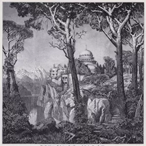
Framed Print : Map of Arrondissement De Belfort, France


![]()
Framed Photos from Liszt Collection
Map of Arrondissement De Belfort, France
Liszt Collection of nineteenth-century engravings and images to browse and enjoy
Media ID 12974969
© Quint Lox Limited
14"x12" (38x32cm) Modern Frame
Discover the historical charm of Arrondissement De Belfort, France, with our stunning framed print from the Liszt Collection. This intricately detailed map, titled "Map of Arrondissement De Belfort, France" by 000030, is a beautiful addition to any home or office. The high-quality print is expertly framed in a sleek and modern design, enhancing the map's rich colors and intricate lines. Bring a piece of French history into your space with this captivating framed print from Media Storehouse.
Wood effect frame, card mounted, 10x8 archival quality photo print. Overall outside dimensions 14x12 inches (38x32cm). Environmentally and ozone friendly, 40mm wide x 15mm Polycore® moulding has the look of real wood, is durable and light and easy to hang. Biodegradable and made with non-chlorinated gases (no toxic fumes) it is efficient; producing 100 tons of polystyrene can save 300 tons of trees! Prints are glazed with lightweight, shatterproof, optical clarity acrylic (providing the same general protection from the environment as glass). The back is stapled hardboard with a sawtooth hanger attached. Note: To minimise original artwork cropping, for optimum layout, and to ensure print is secure, the visible print may be marginally smaller
Contemporary Framed and Mounted Prints - Professionally Made and Ready to Hang
Estimated Image Size (if not cropped) is 17.8cm x 24.4cm (7" x 9.6")
Estimated Product Size is 32.5cm x 37.6cm (12.8" x 14.8")
These are individually made so all sizes are approximate
Artwork printed orientated as per the preview above, with portrait (vertical) orientation to match the source image.
EDITORS COMMENTS
This print showcases a vintage map of Arrondissement De Belfort, France, dating back to the nineteenth century. The intricate engravement and illustrative technique used in this piece highlight the rich history and cultural significance of this region. With its retro-styled design and Victorian charm, it transports us to a bygone era. The Map of Arrondissement De Belfort is meticulously detailed, capturing every street, landmark, and boundary with precision. It offers a fascinating glimpse into the past, allowing us to explore the city's layout as it existed centuries ago. This engraving serves as a testament to the artistic skill and craftsmanship prevalent during that time. As we delve into this historical artifact from Arkheia's Liszt Collection, we are reminded of how maps have always been essential tools for navigation and understanding our surroundings. They provide valuable insights into the development and evolution of cities like Belfort. Whether you are an avid collector or simply appreciate vintage art pieces that encapsulate culture and heritage, this print is sure to captivate your imagination. Its retro aesthetic adds a touch of nostalgia while preserving an important slice of French history. Displaying this unique artwork in your home or office will not only enhance your decor but also spark conversations about Belfort's past. Let yourself be transported back in time through this enchanting visual representation of Arrondissement De Belfort's streetscape from long ago.
MADE IN THE UK
Safe Shipping with 30 Day Money Back Guarantee
FREE PERSONALISATION*
We are proud to offer a range of customisation features including Personalised Captions, Color Filters and Picture Zoom Tools
SECURE PAYMENTS
We happily accept a wide range of payment options so you can pay for the things you need in the way that is most convenient for you
* Options may vary by product and licensing agreement. Zoomed Pictures can be adjusted in the Basket.