Framed Print > Arts > Artists > C > Samuel de Champlain
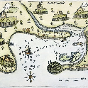
Framed Print : PLYMOUTH, MA, MAP 1605. Samuel de Champlains map of Port St. Louis, later settled by the English as Plymouth, Massachusetts, drawn during an expedetion of 1605


![]()
Framed Photos from Granger
PLYMOUTH, MA, MAP 1605. Samuel de Champlains map of Port St. Louis, later settled by the English as Plymouth, Massachusetts, drawn during an expedetion of 1605
PLYMOUTH, MA, MAP 1605.
Samuel de Champlains map of Port St. Louis, later settled by the English as Plymouth, Massachusetts, drawn during an expedetion of 1605
Granger holds millions of images spanning more than 25,000 years of world history, from before the Stone Age to the dawn of the Space Age
Media ID 6622567
1605 Champlain Colony Samuel Settlement Topography Wood Cut
14"x12" (38x32cm) Modern Frame
Discover the rich history of Plymouth, Massachusetts, with our stunning Framed Print from Media Storehouse. This exclusive piece features an authentic reproduction of Samuel de Champlains map of Port St. Louis, drawn during his expedition in 1605. Later, this location would become known as Plymouth, the site of the English colonists' first successful settlement in New England. Bring a piece of historical significance into your home or office with this beautifully framed print, sourced from The Granger Collection in New York. The intricate details of the map are captured in high resolution, allowing you to explore every corner of this fascinating piece. Add an element of history, art, and culture to your space with the PLYMOUTH, MA, MAP 1605 Framed Print from Media Storehouse. Order yours today and step back in time.
Wood effect frame, card mounted, 10x8 archival quality photo print. Overall outside dimensions 14x12 inches (38x32cm). Environmentally and ozone friendly, 40mm wide x 15mm Polycore® moulding has the look of real wood, is durable and light and easy to hang. Biodegradable and made with non-chlorinated gases (no toxic fumes) it is efficient; producing 100 tons of polystyrene can save 300 tons of trees! Prints are glazed with lightweight, shatterproof, optical clarity acrylic (providing the same general protection from the environment as glass). The back is stapled hardboard with a sawtooth hanger attached. Note: To minimise original artwork cropping, for optimum layout, and to ensure print is secure, the visible print may be marginally smaller
Contemporary Framed and Mounted Prints - Professionally Made and Ready to Hang
Estimated Image Size (if not cropped) is 24.4cm x 17.1cm (9.6" x 6.7")
Estimated Product Size is 37.6cm x 32.5cm (14.8" x 12.8")
These are individually made so all sizes are approximate
Artwork printed orientated as per the preview above, with landscape (horizontal) orientation to match the source image.
FEATURES IN THESE COLLECTIONS
> Arts
> Artists
> C
> Samuel de Champlain
> Arts
> Landscape paintings
> Waterfall and river artworks
> River artworks
> Maps and Charts
> Related Images
> North America
> Related Images
> Granger Art on Demand
> Maps
EDITORS COMMENTS
This print showcases Samuel de Champlain's map of Port St. Louis, which would later become known as Plymouth, Massachusetts. Created during his 1605 expedition, this woodcut map provides a fascinating glimpse into the early settlement and colonization of North America. Champlain's meticulous attention to detail is evident in this topographical masterpiece. The intricate lines and precise markings reveal the contours of the land, highlighting the river that flows through Port St. Louis. This map serves as both a historical document and a work of art, capturing an important moment in American history. The significance of this map lies not only in its accuracy but also in its connection to the English settlers who would eventually make Plymouth their home. It symbolizes the beginning of a new chapter for these colonists as they embarked on their journey towards establishing one of the most influential colonies in American history. As we gaze upon this remarkable piece from The Granger Collection, New York, we are transported back to 1605 when exploration and discovery were at their peak. It reminds us of our roots and how far we have come since those early days. Whether you are an avid historian or simply appreciate beautiful artwork, this print encapsulates both elements seamlessly. It serves as a reminder that every place has its own unique story waiting to be uncovered and shared with future generations.
MADE IN THE UK
Safe Shipping with 30 Day Money Back Guarantee
FREE PERSONALISATION*
We are proud to offer a range of customisation features including Personalised Captions, Color Filters and Picture Zoom Tools
SECURE PAYMENTS
We happily accept a wide range of payment options so you can pay for the things you need in the way that is most convenient for you
* Options may vary by product and licensing agreement. Zoomed Pictures can be adjusted in the Basket.