Framed Print > Africa > Central African Republic > Maps
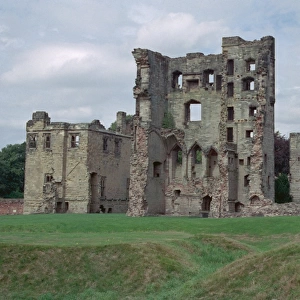
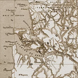
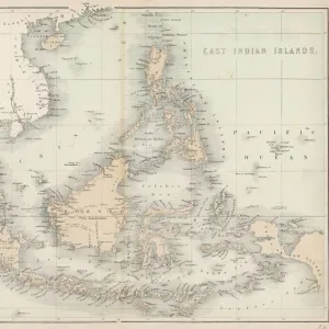
Framed Print : Congo map, central Africa from 1895


![]()
Framed Photos from Fine Art Storehouse
Congo map, central Africa from 1895
Illustration of a Congo map, central Africa from 1895
Unleash your creativity and transform your space into a visual masterpiece!
Nastasic
Media ID 13750425
© This content is subject to copyright
1890 1899 1895 Atlas Mythological Figure Central Africa Democratic Republic Of The Congo Guinea Morocco Paper Sahara Desert Serbia World Map Equatorial Guinea Republic Of The Congo
14"x12" (38x32cm) Modern Frame
Step back in time with our exquisite Framed Print of the "Congo Map, Central Africa from 1895" by Nastasic from our Fine Art Storehouse collection. This captivating piece transports you to a bygone era, providing a historical glimpse into the geography of Central Africa during the late 19th century. The intricate detailing of the map, with its bold lines and vivid colors, makes it an essential addition to any home or office space. Our high-quality Framed Print is meticulously crafted to preserve the beauty and authenticity of the original artwork, ensuring that you can enjoy this piece of history for years to come.
Wood effect frame, card mounted, 10x8 archival quality photo print. Overall outside dimensions 14x12 inches (38x32cm). Environmentally and ozone friendly, 40mm wide x 15mm Polycore® moulding has the look of real wood, is durable and light and easy to hang. Biodegradable and made with non-chlorinated gases (no toxic fumes) it is efficient; producing 100 tons of polystyrene can save 300 tons of trees! Prints are glazed with lightweight, shatterproof, optical clarity acrylic (providing the same general protection from the environment as glass). The back is stapled hardboard with a sawtooth hanger attached. Note: To minimise original artwork cropping, for optimum layout, and to ensure print is secure, the visible print may be marginally smaller
Contemporary Framed and Mounted Prints - Professionally Made and Ready to Hang
Estimated Image Size (if not cropped) is 24.4cm x 19.1cm (9.6" x 7.5")
Estimated Product Size is 37.6cm x 32.5cm (14.8" x 12.8")
These are individually made so all sizes are approximate
Artwork printed orientated as per the preview above, with landscape (horizontal) orientation to match the source image.
FEATURES IN THESE COLLECTIONS
> Fine Art Storehouse
> Map
> Historical Maps
> Fine Art Storehouse
> Travel Imagery
> Travel Destinations
> Morocco, North Africa
> Fine Art Storehouse
> Ultimate Earth Prints
> Amazing Deserts
> Africa
> Central African Republic
> Maps
> Africa
> Central African Republic
> Related Images
> Africa
> Democratic Republic of the Congo
> Related Images
> Africa
> Equatorial Guinea
> Maps
> Africa
> Equatorial Guinea
> Related Images
> Africa
> Guinea
> Related Images
> Africa
> Morocco
> Related Images
> Africa
> Related Images
EDITORS COMMENTS
This print showcases an exquisite illustration of a Congo map from 1895, offering a glimpse into the historical cartography of central Africa. The intricate details and precision engraving transport us back to a time when maps were meticulously crafted by hand. The map encompasses various countries including Serbia, the USA, Equatorial Guinea, Democratic Republic of the Congo, Republic of the Congo, Morocco, and Guinea. It also highlights significant geographical features such as the Sahara Desert. This antique piece serves as a testament to the evolution of physical geography over time. The artist's skillful use of illustration techniques brings this old-world map to life on paper. Every line and contour is delicately etched with care and expertise. As we explore this enchanting artwork, it becomes evident that it not only represents geographic accuracy but also serves as a window into history. Beyond its practical purpose as a navigational tool in its era, this map holds cultural significance too. It reminds us of how our understanding of the world has evolved throughout centuries. Nastasic's remarkable creation captures both artistry and functionality in one frame—a true masterpiece that transports us through time while igniting curiosity about our planet's past exploration and discovery.
MADE IN THE UK
Safe Shipping with 30 Day Money Back Guarantee
FREE PERSONALISATION*
We are proud to offer a range of customisation features including Personalised Captions, Color Filters and Picture Zoom Tools
SECURE PAYMENTS
We happily accept a wide range of payment options so you can pay for the things you need in the way that is most convenient for you
* Options may vary by product and licensing agreement. Zoomed Pictures can be adjusted in the Basket.