Framed Print > Asia > Georgia > Maps
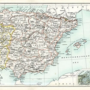
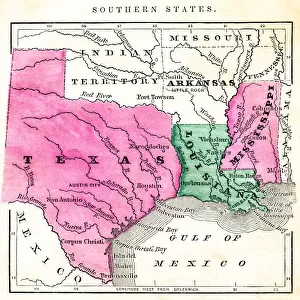
Framed Print : Map of Southern States USA 1877


![]()
Framed Photos from Fine Art Storehouse
Map of Southern States USA 1877
Warrens Common School Geography 1877
Unleash your creativity and transform your space into a visual masterpiece!
THEPALMER
Media ID 14824593
© This content is subject to copyright
Alabama Arkansas Florida Georgia Louisiana Mississippi North Carolina South Carolina Tennessee
14"x12" (38x32cm) Modern Frame
Step back in time with our exquisite Framed Print of "Map of Southern States USA 1877" by THEPALMER from the Media Storehouse Fine Art Collection. This captivating vintage map, originally published in Warrens Common School Geography of 1877, adds an intriguing historical touch to any room. The intricate details of the map, showcasing the Southern States during a pivotal era in American history, are beautifully preserved behind a high-quality frame. Bring a piece of the past into your home and ignite conversations with this stunning and authentic work of art.
Wood effect frame, card mounted, 10x8 archival quality photo print. Overall outside dimensions 14x12 inches (38x32cm). Environmentally and ozone friendly, 40mm wide x 15mm Polycore® moulding has the look of real wood, is durable and light and easy to hang. Biodegradable and made with non-chlorinated gases (no toxic fumes) it is efficient; producing 100 tons of polystyrene can save 300 tons of trees! Prints are glazed with lightweight, shatterproof, optical clarity acrylic (providing the same general protection from the environment as glass). The back is stapled hardboard with a sawtooth hanger attached. Note: To minimise original artwork cropping, for optimum layout, and to ensure print is secure, the visible print may be marginally smaller
Contemporary Framed and Mounted Prints - Professionally Made and Ready to Hang
Estimated Image Size (if not cropped) is 24.4cm x 20.1cm (9.6" x 7.9")
Estimated Product Size is 37.6cm x 32.5cm (14.8" x 12.8")
These are individually made so all sizes are approximate
Artwork printed orientated as per the preview above, with landscape (horizontal) orientation to match the source image.
FEATURES IN THESE COLLECTIONS
> Fine Art Storehouse
> Map
> Historical Maps
> Fine Art Storehouse
> Map
> USA Maps
> USA Southern States Historical Maps
> Fine Art Storehouse
> Map
> USA Maps
> Asia
> Georgia
> Related Images
> Maps and Charts
> Related Images
> North America
> United States of America
> Alabama
> Related Images
> North America
> United States of America
> Arkansas
> Related Images
> North America
> United States of America
> Florida
> Related Images
> North America
> United States of America
> Georgia
> Related Images
> North America
> United States of America
> Louisiana
> Related Images
> North America
> United States of America
> Maps
EDITORS COMMENTS
In this print titled "Map of Southern States USA 1877" we are transported back in time to the post-Civil War era. The intricate details and vibrant colors bring to life a historical artifact from Warrens Common School Geography, published in 1877. This map offers a fascinating glimpse into the geography of the southern states during that period. The map showcases Mississippi, Alabama, Arkansas, Florida, Georgia, Louisiana, North Carolina, South Carolina, and Tennessee with utmost precision. It serves as a testament to the cartographic skills of its creator while also providing valuable insights into the political boundaries and topographical features of these states. As we examine this piece closely by THEPALMER from Fine Art Storehouse, it becomes apparent that every line and contour has been meticulously crafted. The attention to detail is remarkable; one can almost trace their fingers along each river or mountain range depicted on the map. Beyond its aesthetic appeal lies a deeper narrative about America's history. This particular snapshot captures an important moment when these southern states were rebuilding themselves after years of conflict and division caused by the Civil War. It reminds us of how far we have come as a nation since those tumultuous times. "The Map of Southern States USA 1877" is not merely an artwork but also an educational tool that sparks curiosity about our past. Its presence on display invites viewers to explore history through cartography—a visual journey through time that connects us with our roots and encourages reflection upon how geography shapes our collective identity.
MADE IN THE UK
Safe Shipping with 30 Day Money Back Guarantee
FREE PERSONALISATION*
We are proud to offer a range of customisation features including Personalised Captions, Color Filters and Picture Zoom Tools
SECURE PAYMENTS
We happily accept a wide range of payment options so you can pay for the things you need in the way that is most convenient for you
* Options may vary by product and licensing agreement. Zoomed Pictures can be adjusted in the Basket.