Framed Print > Africa > Algeria > Maps
Framed Print : Map of Libya


![]()
Framed Photos from Fine Art Storehouse
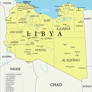
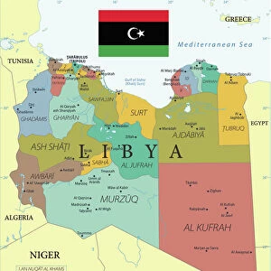
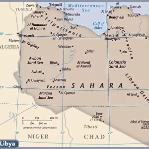
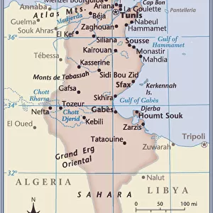
Map of Libya
Reference Map of Libya
Unleash your creativity and transform your space into a visual masterpiece!
Media ID 19813353
Illustration Illustrations Vector Illustrations
14"x12" (38x32cm) Modern Frame
Wood effect frame, card mounted, 10x8 archival quality photo print. Overall outside dimensions 14x12 inches (38x32cm). Environmentally and ozone friendly, 40mm wide x 15mm Polycore® moulding has the look of real wood, is durable and light and easy to hang. Biodegradable and made with non-chlorinated gases (no toxic fumes) it is efficient; producing 100 tons of polystyrene can save 300 tons of trees! Prints are glazed with lightweight, shatterproof, optical clarity acrylic (providing the same general protection from the environment as glass). The back is stapled hardboard with a sawtooth hanger attached. Note: To minimise original artwork cropping, for optimum layout, and to ensure print is secure, the visible print may be marginally smaller
Contemporary Framed and Mounted Prints - Professionally Made and Ready to Hang
Estimated Image Size (if not cropped) is 20.4cm x 24.4cm (8" x 9.6")
Estimated Product Size is 32.5cm x 37.6cm (12.8" x 14.8")
These are individually made so all sizes are approximate
Artwork printed orientated as per the preview above, with portrait (vertical) orientation to match the source image.
FEATURES IN THESE COLLECTIONS
> Fine Art Storehouse
> Map
> Reference Maps
> Africa
> Algeria
> Related Images
> Africa
> Chad
> Related Images
> Africa
> Egypt
> Related Images
> Africa
> Libya
> Related Images
EDITORS COMMENTS
This print showcases a meticulously detailed "Map of Libya" that takes us on an enchanting journey through the diverse landscapes and political boundaries of this North African nation. The reference map, beautifully illustrated with precision and artistry, offers a comprehensive view of Libya's topography, outlining its borders with neighboring countries such as Sudan, Algeria, Chad, Niger, Tunisia, and Egypt. The monochromatic color scheme adds an elegant touch to the composition; shades of blue gracefully depict rivers while grey hues highlight cities like Benghazi and Misurata. This vertical vector illustration masterfully captures not only the physical geography but also the intricate politics and government structures within Libya. Aesthetically pleasing in its simplicity yet rich in information, this map print is perfect for those seeking both decorative beauty and educational value. Whether displayed in a classroom or adorning your living space at home, it serves as a constant reminder of the historical significance and cultural diversity found within this Middle Eastern gem
MADE IN THE UK
Safe Shipping with 30 Day Money Back Guarantee
FREE PERSONALISATION*
We are proud to offer a range of customisation features including Personalised Captions, Color Filters and Picture Zoom Tools
SECURE PAYMENTS
We happily accept a wide range of payment options so you can pay for the things you need in the way that is most convenient for you
* Options may vary by product and licensing agreement. Zoomed Pictures can be adjusted in the Basket.