Framed Print > South America > Brazil > Maps
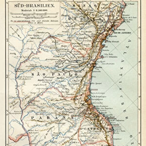
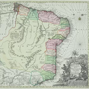
Framed Print : Brazil map 1895


![]()
Framed Photos from Fine Art Storehouse
Brazil map 1895
Meyers Konversations-Lexikon. Ein Nachschlagewerk des allgemeinen Wissens, 5th edition 17 volumes Bibliographisches Institut - Leipzig 1895-1897
Unleash your creativity and transform your space into a visual masterpiece!
THEPALMER
Media ID 13611997
© This content is subject to copyright
Amazon Region Brazil Paper Parana State Sao Paulo South America World Map Amazon Parana Sao Paulo State
14"x12" (38x32cm) Modern Frame
Discover the rich history of Brazil with our stunning Framed Print of the 1895 Brazil Map by THEPALMER from the Fine Art Storehouse. This beautiful antique map, originally published in the prestigious Meyers Konversations-Lexikon, showcases the geography and political boundaries of Brazil during a pivotal period in its history. The intricate details and vintage aesthetic make this a captivating addition to any home or office, perfect for history enthusiasts or those with a passion for cartography. Bring the past to life with this unique and authentic piece of historical art.
Wood effect frame, card mounted, 10x8 archival quality photo print. Overall outside dimensions 14x12 inches (38x32cm). Environmentally and ozone friendly, 40mm wide x 15mm Polycore® moulding has the look of real wood, is durable and light and easy to hang. Biodegradable and made with non-chlorinated gases (no toxic fumes) it is efficient; producing 100 tons of polystyrene can save 300 tons of trees! Prints are glazed with lightweight, shatterproof, optical clarity acrylic (providing the same general protection from the environment as glass). The back is stapled hardboard with a sawtooth hanger attached. Note: To minimise original artwork cropping, for optimum layout, and to ensure print is secure, the visible print may be marginally smaller
Contemporary Framed and Mounted Prints - Professionally Made and Ready to Hang
Estimated Image Size (if not cropped) is 20.5cm x 24.4cm (8.1" x 9.6")
Estimated Product Size is 32.5cm x 37.6cm (12.8" x 14.8")
These are individually made so all sizes are approximate
Artwork printed orientated as per the preview above, with portrait (vertical) orientation to match the source image.
FEATURES IN THESE COLLECTIONS
> Fine Art Storehouse
> The Magical World of Illustration
> Palmer Illustrated Collection
> Fine Art Storehouse
> Map
> Historical Maps
> Maps and Charts
> Related Images
> Maps and Charts
> World
> North America
> United States of America
> Maps
> South America
> Brazil
> Maps
> South America
> Brazil
> Related Images
> South America
> Brazil
> Sao Paulo
> South America
> Related Images
EDITORS COMMENTS
This print showcases a remarkable piece of history - the Brazil map from 1895. Taken from the renowned Meyers Konversations-Lexikon, an esteemed encyclopedia of general knowledge, this particular edition was published in Leipzig between 1895 and 1897. The map itself provides a fascinating glimpse into the past, depicting various regions including Amazon, Brazil, Parana, Sao Paulo, and South America. Printed on high-quality paper with exquisite attention to detail, this vertical composition captures the essence of cartography during that era. The intricate engraving and illustration techniques employed in its creation make it truly unique and reminiscent of antique maps cherished by collectors worldwide. Beyond its aesthetic appeal lies a wealth of historical significance. This old-world map not only offers insights into physical geography but also serves as a testament to the evolving boundaries and political landscapes at that time. It takes us back to an era when exploration was paramount and world maps were essential tools for understanding our planet. Whether you are an avid collector or simply appreciate fine art pieces with historical value, this Brazil map print is sure to captivate your imagination. Its presence on any wall will undoubtedly spark conversations about our ever-changing world while honoring the craftsmanship of yesteryears' cartographers.
MADE IN THE UK
Safe Shipping with 30 Day Money Back Guarantee
FREE PERSONALISATION*
We are proud to offer a range of customisation features including Personalised Captions, Color Filters and Picture Zoom Tools
SECURE PAYMENTS
We happily accept a wide range of payment options so you can pay for the things you need in the way that is most convenient for you
* Options may vary by product and licensing agreement. Zoomed Pictures can be adjusted in the Basket.