Framed Print > Fine Art Finder > Artists > Sebastien Le Prestre de Vauban
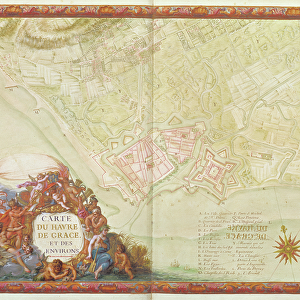
Framed Print : Ms. 986, Vol. 3 fol. 63 Plan and Map of Toulon, from the Atlas Louis XIV


Please select a smaller print size for this image
![]()
Framed Photos from Fine Art Finder
Ms. 986, Vol. 3 fol. 63 Plan and Map of Toulon, from the Atlas Louis XIV
XIR232100 Ms. 986, Vol.3 fol.63 Plan and Map of Toulon, from the Atlas Louis XIV, 1683-88 (gouache on paper) by Vauban, Sebastien Le Prestre de (1633-1707); Min. Defense - Service Historique de l Armee de Terre, France; French, out of copyright
Media ID 12766908
© www.bridgemanimages.com
14"x12" (38x32cm) Modern Frame
Discover historical depth with our Framed Prints from Media Storehouse, featuring the exquisite Ms. 986, Vol. 3 fol. 63 Plan and Map of Toulon from the Atlas Louis XIV. This stunning piece, created by renowned French military engineer Sebastien Le Prestre de Vauban in 1683-88, showcases a meticulously detailed gouache on paper plan and map of Toulon. Bring a piece of the past into your home or office with this beautiful, museum-quality framed print from Bridgeman Images, available through Fine Art Finder.
Wood effect frame, card mounted, 10x8 archival quality photo print. Overall outside dimensions 14x12 inches (38x32cm). Environmentally and ozone friendly, 40mm wide x 15mm Polycore® moulding has the look of real wood, is durable and light and easy to hang. Biodegradable and made with non-chlorinated gases (no toxic fumes) it is efficient; producing 100 tons of polystyrene can save 300 tons of trees! Prints are glazed with lightweight, shatterproof, optical clarity acrylic (providing the same general protection from the environment as glass). The back is stapled hardboard with a sawtooth hanger attached. Note: To minimise original artwork cropping, for optimum layout, and to ensure print is secure, the visible print may be marginally smaller
Contemporary Framed and Mounted Prints - Professionally Made and Ready to Hang
Estimated Image Size (if not cropped) is 24.4cm x 17.7cm (9.6" x 7")
Estimated Product Size is 37.6cm x 32.5cm (14.8" x 12.8")
These are individually made so all sizes are approximate
Artwork printed orientated as per the preview above, with landscape (horizontal) orientation to match the source image.
EDITORS COMMENTS
This print showcases the intricate "Plan and Map of Toulon" from the renowned Atlas Louis XIV, created by Sebastien Le Prestre de Vauban in 1683-88. The stunning gouache on paper artwork provides a fascinating glimpse into the fortified city of Toulon, located in France. The image captures the meticulous details of this historical map, revealing the strategic layout of bastions and town structures that were crucial for defense during that era. Vauban's expertise as a military engineer is evident in his precise depiction of every street, building, and wall within Toulon. As we delve into this mesmerizing piece, we are transported back to a time when cities were meticulously planned with defensive strategies in mind. The artistry and craftsmanship displayed here truly exemplify the talents of Vauban as he sought to protect France's territories. This remarkable print not only serves as an aesthetic delight but also offers valuable insights into French history and architecture. It reminds us of the importance placed on fortifications during times of conflict and highlights how these structures played a vital role in safeguarding cities like Toulon. With its rich historical significance and artistic brilliance, this image invites us to appreciate both the beauty and functionality behind such cartographic masterpieces.
MADE IN THE UK
Safe Shipping with 30 Day Money Back Guarantee
FREE PERSONALISATION*
We are proud to offer a range of customisation features including Personalised Captions, Color Filters and Picture Zoom Tools
SECURE PAYMENTS
We happily accept a wide range of payment options so you can pay for the things you need in the way that is most convenient for you
* Options may vary by product and licensing agreement. Zoomed Pictures can be adjusted in the Basket.