Framed Print > Fine Art Finder > Artists > Charles Marie Rigobert Bonne
Framed Print : France by Regions, from Atlas de Toutes les Parties Connues du Globe Terrestre


Please select a smaller print size for this image
![]()
Framed Photos from Fine Art Finder
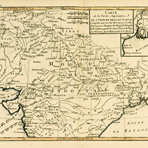
France by Regions, from Atlas de Toutes les Parties Connues du Globe Terrestre
KW206608 France by Regions, from Atlas de Toutes les Parties Connues du Globe Terrestre by Guillaume Raynal (1713-96) published 1780 (coloured engraving) by Bonne, Charles Marie Rigobert (1727-95); Private Collection; Ken Welsh; French, out of copyright
Media ID 12755753
© www.bridgemanimages.com
14"x12" (38x32cm) Modern Frame
Discover the timeless beauty of France with our Framed Prints from Media Storehouse. Featuring an exquisite engraving from "France by Regions" by Guillaume Raynal, published in 1780, these prints showcase the captivating regions of France as depicted in the classic atlas "Atlas de Toutes les Parties Connues du Globe Terrestre". Each print is meticulously framed to preserve the intricate details of the coloured engraving from Bridgeman Images, bringing a touch of old-world charm and elegance to your home or office. Transport yourself to the heart of France's rich history and culture with these stunning Framed Prints.
Wood effect frame, card mounted, 10x8 archival quality photo print. Overall outside dimensions 14x12 inches (38x32cm). Environmentally and ozone friendly, 40mm wide x 15mm Polycore® moulding has the look of real wood, is durable and light and easy to hang. Biodegradable and made with non-chlorinated gases (no toxic fumes) it is efficient; producing 100 tons of polystyrene can save 300 tons of trees! Prints are glazed with lightweight, shatterproof, optical clarity acrylic (providing the same general protection from the environment as glass). The back is stapled hardboard with a sawtooth hanger attached. Note: To minimise original artwork cropping, for optimum layout, and to ensure print is secure, the visible print may be marginally smaller
Contemporary Framed and Mounted Prints - Professionally Made and Ready to Hang
Estimated Image Size (if not cropped) is 24.4cm x 16.9cm (9.6" x 6.7")
Estimated Product Size is 37.6cm x 32.5cm (14.8" x 12.8")
These are individually made so all sizes are approximate
Artwork printed orientated as per the preview above, with landscape (horizontal) orientation to match the source image.
EDITORS COMMENTS
This print showcases the intricate details of "France by Regions" from the renowned Atlas de Toutes les Parties Connues du Globe Terrestre. Created by Guillaume Raynal and published in 1780, this coloured engraving offers a glimpse into the geographical divisions of France during that era. The artist behind this masterpiece is Charles Marie Rigobert Bonne, whose exceptional talent shines through in every stroke. The map takes us on a visual journey across France's diverse regions, each marked with precision and elegance. From the rugged coastlines of Brittany to the rolling hills of Provence, this print captures the essence and beauty of each area. The vibrant colors bring life to the landscapes, evoking a sense of awe and wonder. As we gaze upon this historic piece, we are transported back in time to an era when cartography was both artistry and science. It serves as a reminder of how far we have come in our understanding and exploration of our planet. This print is part of a private collection curated by Ken Welsh, who has dedicated his passion for fine art to preserve these timeless treasures for future generations. Through www. bridgemanimages. com, we can now appreciate and admire these works from the comfort of our own homes. Whether you are an avid history enthusiast or simply captivated by beautiful artwork, this print is sure to be a cherished addition to any collection.
MADE IN THE UK
Safe Shipping with 30 Day Money Back Guarantee
FREE PERSONALISATION*
We are proud to offer a range of customisation features including Personalised Captions, Color Filters and Picture Zoom Tools
SECURE PAYMENTS
We happily accept a wide range of payment options so you can pay for the things you need in the way that is most convenient for you
* Options may vary by product and licensing agreement. Zoomed Pictures can be adjusted in the Basket.