Framed Print > Fine Art Finder > Artists > Charles Marie Rigobert Bonne
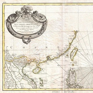
Framed Print : The Chinese Empire, Chinese Tartary and the Kingdom of Korea, with the Islands of Japan


Please select a smaller print size for this image
![]()
Framed Photos from Fine Art Finder
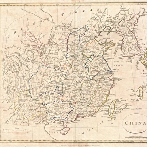
The Chinese Empire, Chinese Tartary and the Kingdom of Korea, with the Islands of Japan
KW206604 The Chinese Empire, Chinese Tartary and the Kingdom of Korea, with the Islands of Japan, from Atlas de Toutes les Parties Connues du Globe Terrestre by Guillaume Raynal (1713-96) published 1780 (coloured engraving) by Bonne, Charles Marie Rigobert (1727-95); Private Collection; Ken Welsh; French, out of copyright
Media ID 12755743
© www.bridgemanimages.com
22"x18" (58x48cm) Modern Frame
Bring the rich history of Asian geography into your home or office with our exquisite Framed Prints from Media Storehouse. This stunning piece, titled "The Chinese Empire, Chinese Tartary and the Kingdom of Korea, with the Islands of Japan," is an authentic reproduction of an original map from Atlas de Toutes les Parties Connues du Globe Terrestre by Guillaume Raynal (1713-96), as featured on Fine Art Finder and Bridgeman Images (KW206604). The intricate detail and vibrant colors of this antique map transport you back in time, making it a captivating conversation starter and a beautiful addition to any decor. Order your Framed Print today and let the story of the East unfold in your space.
Wood effect frame, card mounted, 16x12 archival quality photo print. Overall outside dimensions 22x18 inches (58x48cm). Environmentally and ozone friendly, 40mm wide x 15mm Polycore® moulding has the look of real wood, is durable and light and easy to hang. Biodegradable and made with non-chlorinated gases (no toxic fumes) it is efficient; producing 100 tons of polystyrene can save 300 tons of trees! Prints are glazed with lightweight, shatterproof, optical clarity acrylic (providing the same general protection from the environment as glass). The back is stapled hardboard with a sawtooth hanger attached. Note: To minimise original artwork cropping, for optimum layout, and to ensure print is secure, the visible print may be marginally smaller
Contemporary Framed and Mounted Prints - Professionally Made and Ready to Hang
Estimated Image Size (if not cropped) is 26.9cm x 39.6cm (10.6" x 15.6")
Estimated Product Size is 47.8cm x 57.9cm (18.8" x 22.8")
These are individually made so all sizes are approximate
Artwork printed orientated as per the preview above, with portrait (vertical) orientation to match the source image.
EDITORS COMMENTS
This print, titled "The Chinese Empire, Chinese Tartary and the Kingdom of Korea, with the Islands of Japan" takes us on a visual journey through the vast lands of East Asia. Created by Guillaume Raynal in 1780 and beautifully engraved by Charles Marie Rigobert Bonne, this coloured engraving offers a glimpse into the intricate cartography of its time. The map showcases the expansive territories that once constituted the mighty Chinese Empire, stretching from China proper to Chinese Tartary and encompassing the Kingdom of Korea. The inclusion of Japan's islands further enriches this historical snapshot. With meticulous detail and vibrant colors, this print not only serves as a geographical reference but also provides insight into cultural connections between these nations. It invites contemplation on how trade routes were established across land and sea during this era. As we admire this piece from our private collection today, it reminds us of the importance placed on exploration and knowledge-sharing throughout history. It is a testament to human curiosity and our innate desire to understand distant lands. This remarkable artwork allows us to appreciate both its aesthetic appeal as well as its historical significance. It serves as a reminder that art can be an invaluable tool for preserving our collective memory while offering endless opportunities for discovery.
MADE IN THE UK
Safe Shipping with 30 Day Money Back Guarantee
FREE PERSONALISATION*
We are proud to offer a range of customisation features including Personalised Captions, Color Filters and Picture Zoom Tools
SECURE PAYMENTS
We happily accept a wide range of payment options so you can pay for the things you need in the way that is most convenient for you
* Options may vary by product and licensing agreement. Zoomed Pictures can be adjusted in the Basket.