Home > Africa > Algeria > Maps
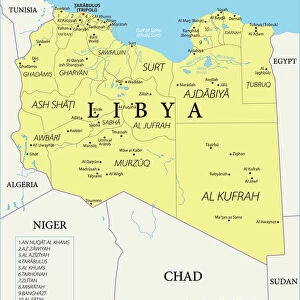
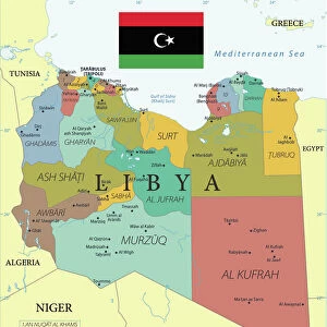
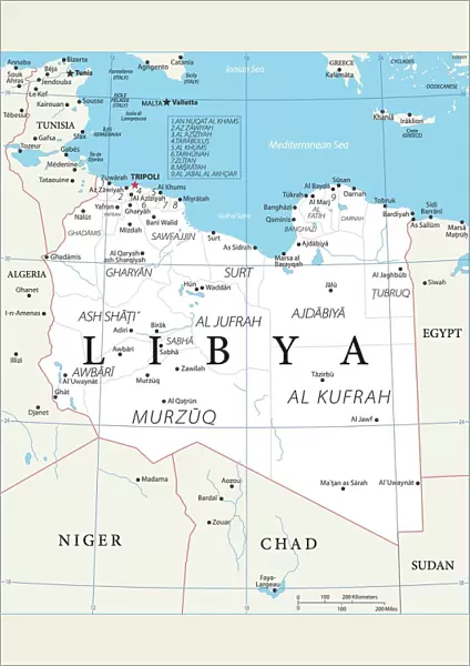
Poster Print : Map of Libya


![]()
Poster Prints from Fine Art Storehouse
Map of Libya
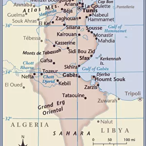
Reference Map of Libya
Unleash your creativity and transform your space into a visual masterpiece!
Media ID 19813353
Illustration Illustrations Vector Illustrations
A4 (29.7 x 21cm) Poster Print
A4 Poster (29.7 x 21cm, 8.3 x 11.7 inches) printed on 170gsm Satin Poster Paper. Securely packaged, rolled and inserted into a strong mailing tube and shipped tracked. Poster Prints are of comparable archival quality to our Photographic prints, they are simply printed on thinner Poster Paper. Whilst we only use Photographic Prints in our frames, you can frame Poster Prints if they are carefully supported to prevent sagging over time.
Poster prints are budget friendly enlarged prints in standard poster paper sizes (A0, A1, A2, A3 etc). Whilst poster paper is sometimes thinner and less durable than our other paper types, they are still ok for framing and should last many years. Our Archival Quality Photo Prints and Fine Art Paper Prints are printed on higher quality paper and the choice of which largely depends on your budget.
Estimated Product Size is 21cm x 29.7cm (8.3" x 11.7")
These are individually made so all sizes are approximate
Artwork printed orientated as per the preview above, with portrait (vertical) orientation to match the source image.
FEATURES IN THESE COLLECTIONS
> Africa
> Algeria
> Related Images
> Africa
> Chad
> Related Images
> Africa
> Egypt
> Related Images
> Africa
> Libya
> Related Images
> Fine Art Storehouse
> Map
> Reference Maps
EDITORS COMMENTS
This print showcases a meticulously detailed "Map of Libya" that takes us on an enchanting journey through the diverse landscapes and political boundaries of this North African nation. The reference map, beautifully illustrated with precision and artistry, offers a comprehensive view of Libya's topography, outlining its borders with neighboring countries such as Sudan, Algeria, Chad, Niger, Tunisia, and Egypt. The monochromatic color scheme adds an elegant touch to the composition; shades of blue gracefully depict rivers while grey hues highlight cities like Benghazi and Misurata. This vertical vector illustration masterfully captures not only the physical geography but also the intricate politics and government structures within Libya. Aesthetically pleasing in its simplicity yet rich in information, this map print is perfect for those seeking both decorative beauty and educational value. Whether displayed in a classroom or adorning your living space at home, it serves as a constant reminder of the historical significance and cultural diversity found within this Middle Eastern gem
MADE IN THE UK
Safe Shipping with 30 Day Money Back Guarantee
FREE PERSONALISATION*
We are proud to offer a range of customisation features including Personalised Captions, Color Filters and Picture Zoom Tools
SECURE PAYMENTS
We happily accept a wide range of payment options so you can pay for the things you need in the way that is most convenient for you
* Options may vary by product and licensing agreement. Zoomed Pictures can be adjusted in the Basket.