Home > Maps and Charts > Americas
1647, antiquity, archival, cartography, colonialism, geographical, geography, historic

![]()
Wall Art and Photo Gifts from Fine Art Storehouse
1647, antiquity, archival, cartography, colonialism, geographical, geography, historic
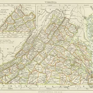
1647, antiquity, archival, cartography, colonialism, geographical, geography, historic, map, nobody, north america, old-fashioned, text, united states, vintage, virginia, Antique Maps, 89687377
Unleash your creativity and transform your space into a visual masterpiece!
Hemera Technologies
Media ID 14761260
© Getty Images
Antiquity Colonialism Geographical Geography North America Text United States Virginia 1647
FEATURES IN THESE COLLECTIONS
> Fine Art Storehouse
> Map
> Historical Maps
> Maps and Charts
> Early Maps
> North America
> Related Images
EDITORS COMMENTS
This print takes us back to the year 1647, immersing us in a world of antiquity and colonialism. The archival map displayed here is a remarkable piece of cartography that showcases the geographical landscape of North America during this historic era. With its old-fashioned charm and intricate details, it offers a glimpse into the past, allowing us to explore the early days of Virginia and the United States. As we study this vintage map, we are transported to a time when exploration and discovery shaped our understanding of the world. The text inscribed on its surface tells stories of brave explorers who ventured into unknown territories, paving the way for future generations. The significance of this antique map goes beyond its aesthetic appeal; it serves as a testament to our rich history and cultural heritage. It reminds us how boundaries were drawn, colonies were established, and nations were born through centuries-long struggles. Hemera Technologies has masterfully captured every nuance in this print, preserving not only an exquisite work of art but also an invaluable historical artifact. As we gaze upon it with wonderment, let's appreciate how far we have come while acknowledging those who came before us - their triumphs and tribulations forever etched onto these delicate lines.
MADE IN THE UK
Safe Shipping with 30 Day Money Back Guarantee
FREE PERSONALISATION*
We are proud to offer a range of customisation features including Personalised Captions, Color Filters and Picture Zoom Tools
SECURE PAYMENTS
We happily accept a wide range of payment options so you can pay for the things you need in the way that is most convenient for you
* Options may vary by product and licensing agreement. Zoomed Pictures can be adjusted in the Basket.