Home > Arts > Street art graffiti > Digital art > Vector illustrations
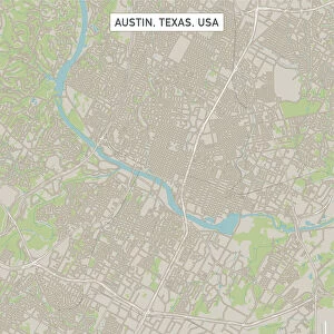
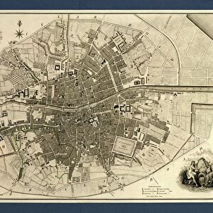
Round Rock Texas US City Street Map

![]()
Wall Art and Photo Gifts from Fine Art Storehouse
Round Rock Texas US City Street Map
Vector Illustration of a City Street Map of Round Rock, Texas, USA. Scale 1:60, 000.
All source data is in the public domain.
U.S. Geological Survey, US Topo
Used Layers:
USGS The National Map: National Hydrography Dataset (NHD)
USGS The National Map: National Transportation Dataset (NTD)
Unleash your creativity and transform your space into a visual masterpiece!
Frank Ramspott
Media ID 15192936
© Frank Ramspott, all rights reserved
Aerial View City Map Computer Graphic Directly Above Downtown District Gray Road Map Texas Text Digitally Generated Image Green Color White Color
FEATURES IN THESE COLLECTIONS
> Aerial Photography
> Related Images
> Animals
> Insects
> Hemiptera
> Green Scale
> Arts
> Contemporary art
> Digital artwork
> Street art
> Arts
> Landscape paintings
> Waterfall and river artworks
> River artworks
> Arts
> Portraits
> Pop art gallery
> Street art portraits
> Arts
> Street art graffiti
> Digital art
> Digital paintings
> Arts
> Street art graffiti
> Digital art
> Vector illustrations
> Fine Art Storehouse
> Map
> Street Maps
> Fine Art Storehouse
> Map
> USA Maps
> Maps and Charts
> Geological Map
> Maps and Charts
> Related Images
> North America
> United States of America
> Lakes
> Related Images
EDITORS COMMENTS
This print showcases a meticulously detailed city street map of Round Rock, Texas, USA. With a scale of 1:60,000, every nook and cranny of this vibrant city is beautifully illustrated in vector format. The artist, Frank Ramspott, has masterfully crafted this digitally generated image using various layers sourced from the public domain. The map incorporates data from the U. S. Geological Survey's National Hydrography Dataset (NHD) and National Transportation Dataset (NTD), ensuring accuracy and reliability. From the bustling downtown district to the serene lake and river that grace its landscape, every element is thoughtfully included. The design features an aerial view directly above Round Rock, allowing viewers to appreciate its physical geography with ease. The color palette blends shades of gray for roads and streets with pops of blue for water bodies and white for text labels. Lush green hues symbolize parks and open spaces throughout the city. With no people present in the image, it solely focuses on showcasing Round Rock's urban layout through intricate cartography techniques. This visually striking piece would be a perfect addition to any art collection or as a gift for those who hold an affinity for maps or have a special connection to this Texan town.
MADE IN THE UK
Safe Shipping with 30 Day Money Back Guarantee
FREE PERSONALISATION*
We are proud to offer a range of customisation features including Personalised Captions, Color Filters and Picture Zoom Tools
SECURE PAYMENTS
We happily accept a wide range of payment options so you can pay for the things you need in the way that is most convenient for you
* Options may vary by product and licensing agreement. Zoomed Pictures can be adjusted in the Basket.