Home > Animals > Reptiles > Snakes > Rattlesnake > Tiger Rattlesnake
MA Norfolk Sharon Vector Road Map

![]()
Wall Art and Photo Gifts from Fine Art Storehouse
MA Norfolk Sharon Vector Road Map
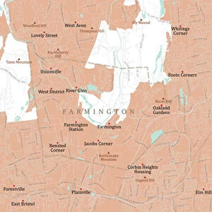
MA Norfolk Sharon Vector Road Map. All source data is in the public domain. U.S. Census Bureau Census Tiger. Used Layers: areawater, linearwater, roads, rails, cousub, pointlm, uac10
Unleash your creativity and transform your space into a visual masterpiece!
Frank Ramspott
Media ID 20692361
© Frank Ramspott, all rights reserved
Canton City Map Computer Graphic County Digital Composite District Geographical Border Massachusetts Norfolk Road Map Text Vector Digitally Generated Image Sharon Stoughton Walpole
FEATURES IN THESE COLLECTIONS
> Animals
> Birds
> Gruiformes
> Rallidae
> Water Rail
> Animals
> Mammals
> Cats (Wild)
> Tiger
> Animals
> Reptiles
> Snakes
> Rattlesnake
> Tiger Rattlesnake
> Arts
> Landscape paintings
> Waterfall and river artworks
> River artworks
> Arts
> Portraits
> Pop art gallery
> Street art portraits
> Arts
> Street art graffiti
> Digital art
> Digital paintings
> Europe
> United Kingdom
> England
> Norfolk
> Related Images
> Fine Art Storehouse
> Map
> Reference Maps
> Maps and Charts
> Related Images
EDITORS COMMENTS
This print showcases the MA Norfolk Sharon Vector Road Map, a stunning piece of cartography art created by Frank Ramspott. The artist has skillfully designed this digitally generated image using various layers sourced from the public domain, including data from the U. S. Census Bureau Census Tiger. The vibrant colors and intricate details bring this map to life, highlighting the physical geography of Massachusetts' Norfolk County district. From bustling cities to serene lakes and rivers, every element is meticulously depicted in this computer graphic masterpiece. While devoid of any human presence, this print immerses viewers into a world of geographical borders and cityscapes. It guides us through well-known areas such as Hobbs Hill, Sharon Heights, Canton, Stoughton, Walpole, and Rattlesnake Hill with clarity and precision. With its clear text labels and comprehensive road network representation, this vector map serves as an invaluable tool for navigation or simply admiring the beauty of our surroundings. Whether you are a lover of maps or appreciate fine digital composites like this one, Frank Ramspott's creation will surely captivate your imagination
MADE IN THE UK
Safe Shipping with 30 Day Money Back Guarantee
FREE PERSONALISATION*
We are proud to offer a range of customisation features including Personalised Captions, Color Filters and Picture Zoom Tools
SECURE PAYMENTS
We happily accept a wide range of payment options so you can pay for the things you need in the way that is most convenient for you
* Options may vary by product and licensing agreement. Zoomed Pictures can be adjusted in the Basket.