Home > Animals > Birds > Gruiformes > Rallidae > Water Rail
MA Barnstable Bourne Vector Road Map

![]()
Wall Art and Photo Gifts from Fine Art Storehouse
MA Barnstable Bourne Vector Road Map
MA Barnstable Bourne Vector Road Map. All source data is in the public domain. U.S. Census Bureau Census Tiger. Used Layers: areawater, linearwater, roads, rails, cousub, pointlm, uac10
Unleash your creativity and transform your space into a visual masterpiece!
Frank Ramspott
Media ID 20688537
© Frank Ramspott, all rights reserved
Atlantic Ocean Barnstable Bourne Buzzards Bay Cape Cod City Map Computer Graphic County Digital Composite District Geographical Border Harbor Massachusetts Riverside Road Map Sandwich Text Vector Digitally Generated Image Onset Sagamore Wareham
FEATURES IN THESE COLLECTIONS
> Animals
> Birds
> Gruiformes
> Rallidae
> Water Rail
> Animals
> Fishes
> A
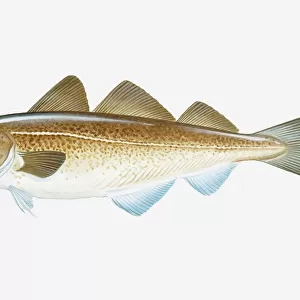
> Atlantic Cod
> Animals
> Mammals
> Cats (Wild)
> Tiger
> Arts
> Landscape paintings
> Waterfall and river artworks
> River artworks
> Arts
> Portraits
> Pop art gallery
> Street art portraits
> Arts
> Street art graffiti
> Digital art
> Digital paintings
> Fine Art Storehouse
> Map
> Reference Maps
> Maps and Charts
> Related Images
EDITORS COMMENTS
This print showcases the MA Barnstable Bourne Vector Road Map, a stunning piece of cartography art created by Frank Ramspott. With all source data obtained from the public domain, this digitally generated image beautifully depicts the intricate details of Massachusetts' Barnstable and Bourne counties. The map's design is a true testament to Ramspott's talent in creating visually appealing and informative compositions. Utilizing various layers such as areawater, linearwater, roads, rails, cousub, pointlm, and uac10 from the U. S. Census Bureau Census Tiger database, he has meticulously crafted a comprehensive representation of this region's physical geography. Vibrant colors bring life to this computer graphic masterpiece while highlighting geographical borders and city landmarks. From bustling towns like Barnstable and Sandwich to picturesque coastal areas along Cape Cod Bay and Buzzards Bay, every element on this map is intricately detailed. Although devoid of people in its composition, this artwork speaks volumes about the rich history and natural beauty that can be found within these regions. Rivers meander gracefully through lush landscapes while lakes shimmer under the warm sun. The Atlantic Ocean majestically embraces Cape Cod's coastline with harbors waiting to welcome sailors home. Whether you're an avid traveler or simply appreciate fine cartographic artistry, this MA Barnstable Bourne Vector Road Map print will surely captivate your imagination with its meticulous detail and vibrant colors.
MADE IN THE UK
Safe Shipping with 30 Day Money Back Guarantee
FREE PERSONALISATION*
We are proud to offer a range of customisation features including Personalised Captions, Color Filters and Picture Zoom Tools
SECURE PAYMENTS
We happily accept a wide range of payment options so you can pay for the things you need in the way that is most convenient for you
* Options may vary by product and licensing agreement. Zoomed Pictures can be adjusted in the Basket.