Home > Animals > Birds > Gruiformes > Rallidae > Water Rail
CT Litchfield Torrington Vector Road Map

![]()
Wall Art and Photo Gifts from Fine Art Storehouse
CT Litchfield Torrington Vector Road Map
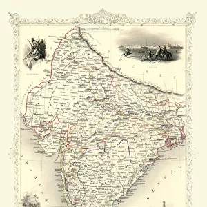
CT Litchfield Torrington Vector Road Map. All source data is in the public domain. U.S. Census Bureau Census Tiger. Used Layers: areawater, linearwater, roads, rails, cousub, pointlm, uac10
Unleash your creativity and transform your space into a visual masterpiece!
Frank Ramspott
Media ID 20687857
© Frank Ramspott, all rights reserved
City Map Computer Graphic Connecticut County Digital Composite District Geographical Border Litchfield Road Map Text Vector Village Digitally Generated Image Newfield Torrington
FEATURES IN THESE COLLECTIONS
> Animals
> Birds
> Gruiformes
> Rallidae
> Water Rail
> Animals
> Mammals
> Cats (Wild)
> Tiger
> Arts
> Landscape paintings
> Waterfall and river artworks
> River artworks
> Arts
> Portraits
> Pop art gallery
> Street art portraits
> Arts
> Street art graffiti
> Digital art
> Digital paintings
> Fine Art Storehouse
> Map
> Reference Maps
> Maps and Charts
> Related Images
EDITORS COMMENTS
This print showcases the intricate details of a CT Litchfield Torrington Vector Road Map, designed by Frank Ramspott. The artist has ingeniously combined various layers of data sourced from the U. S. Census Bureau Census Tiger, including areawater, linearwater, roads, rails, cousub, pointlm, and uac10. This digitally generated image is a testament to the power of cartography and design in creating visually stunning representations of our physical geography. In this vibrant color image, every geographical element comes to life through vector graphics and computer-generated imagery. From cities to towns and villages like Wrightville, Burrville, Newfield, Harwinton, Platt Hill - each location is meticulously labeled with clear text for easy navigation. Rivers gracefully wind their way across the map while lakes shimmer with tranquility. What makes this artwork even more remarkable is its public domain status; all source data used in its creation can be accessed freely by anyone interested in exploring Connecticut's Litchfield County district. While no people are depicted within the frame of this composition—keeping the focus solely on the map itself—the viewer can't help but feel a sense of adventure as they imagine traversing these streets and discovering hidden gems along the way. Frank Ramspott's digital composite beautifully captures both practicality and aesthetic appeal in one frame—a must-have for any map enthusiast or lover of fine art.
MADE IN THE UK
Safe Shipping with 30 Day Money Back Guarantee
FREE PERSONALISATION*
We are proud to offer a range of customisation features including Personalised Captions, Color Filters and Picture Zoom Tools
SECURE PAYMENTS
We happily accept a wide range of payment options so you can pay for the things you need in the way that is most convenient for you
* Options may vary by product and licensing agreement. Zoomed Pictures can be adjusted in the Basket.