Home > North America > United States of America > New York > New York > Maps
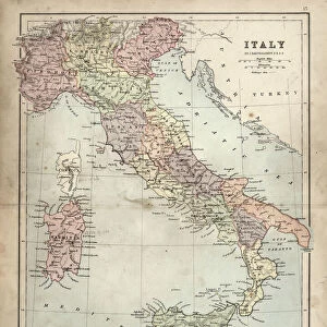
Map of Italy 1894

![]()
Wall Art and Photo Gifts from Fine Art Storehouse
Map of Italy 1894
Johnsons Universal Cyclopedia - Volume IV New York - A. J. Johnson Company 1894
Unleash your creativity and transform your space into a visual masterpiece!
THEPALMER
Media ID 18356731
FEATURES IN THESE COLLECTIONS
> Fine Art Storehouse
> Map
> Historical Maps
> Fine Art Storehouse
> Map
> Italian Maps
> Maps and Charts
> Early Maps
> Maps and Charts
> Italy
> North America
> United States of America
> New York
> New York
> Maps
EDITORS COMMENTS
In this print titled "Map of Italy 1894" we are transported back in time to the late 19th century. The map, sourced from Johnsons Universal Cyclopedia, Volume IV New York, published by A. J. Johnson Company in 1894, offers a fascinating glimpse into Italy's rich history and geographical landscape. The intricate details and delicate craftsmanship of this vintage map immediately draw us in. Every contour line, city name, and topographical feature is meticulously depicted with precision and care. It serves as a testament to the artistry involved in cartography during that era. As we explore the map further, it becomes evident how much has changed over the years. Borders have shifted; cities have grown or transformed; regions have evolved politically and culturally. Yet amidst these changes lies an enduring sense of heritage and tradition that still defines Italy today. The warm sepia tones used in this print add a nostalgic touch, enhancing our connection to the past while reminding us of the passage of time. It invites contemplation on how history shapes our present reality. "The Map of Italy 1894" by THEPALMER captures not only a moment frozen in time but also sparks curiosity about our collective journey as humans across generations. This artwork serves as both an educational resource for geography enthusiasts and a beautiful piece that evokes sentimentality for those with Italian roots or an appreciation for historical artifacts. Whether displayed within homes or public spaces like libraries or classrooms, this print will undoubtedly inspire conversations about
MADE IN THE UK
Safe Shipping with 30 Day Money Back Guarantee
FREE PERSONALISATION*
We are proud to offer a range of customisation features including Personalised Captions, Color Filters and Picture Zoom Tools
SECURE PAYMENTS
We happily accept a wide range of payment options so you can pay for the things you need in the way that is most convenient for you
* Options may vary by product and licensing agreement. Zoomed Pictures can be adjusted in the Basket.