Home > Europe > France > Paris > Maps
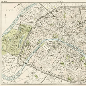
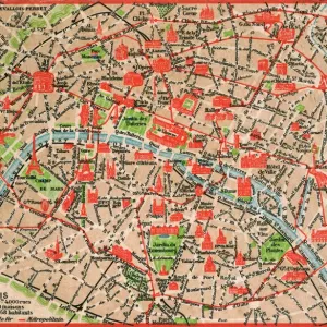
City map of Paris, lithograph, published in 1877

![]()
Wall Art and Photo Gifts from Fine Art Storehouse
City map of Paris, lithograph, published in 1877
City map of Paris, France. Lithograph, published in 1877
Unleash your creativity and transform your space into a visual masterpiece!
Media ID 13666771
© ZU_09
78279 Antiquities City Map City Street Contour Drawing Downtown District French Culture Image Date Paris France Road Map Seine River Stadtzentrum Topographic Map Topography Image Created 19th Century
FEATURES IN THESE COLLECTIONS
> Arts
> Landscape paintings
> Waterfall and river artworks
> River artworks
> Arts
> Portraits
> Pop art gallery
> Street art portraits
> Europe
> France
> Paris
> Maps
> Europe
> France
> Paris
> River Seine
> Fine Art Storehouse
> Map
> Historical Maps
> Maps and Charts
> Early Maps
EDITORS COMMENTS
This lithograph print showcases a city map of Paris, France, as it appeared in 1877. A true testament to the artistry of cartography during the 19th century, this engraved image offers a glimpse into the rich history and ancient charm of the French capital. The topographic map beautifully captures the intricate layout of Paris, from its downtown district to its meandering streets along the iconic Seine River. With meticulous detail and exquisite craftsmanship, this lithograph transports us back in time to an era when maps were not only functional but also works of art. Its horizontal composition allows for a comprehensive view of the city's contours and highlights key landmarks that have shaped French culture throughout centuries. As we gaze upon this old-world treasure, we are reminded of how cities evolve over time while still retaining their unique character. This particular print was created in 1877 but has been preserved with utmost care until today. It serves as a visual bridge between past and present, inviting us to explore Paris through both historical lenses and contemporary perspectives. Whether you are an avid collector or simply appreciate fine antiquities, this lithograph print is sure to captivate your imagination with its timeless beauty and enduring significance. Display it proudly on your wall as a tribute to one of Europe's most enchanting cities – Paris!
MADE IN THE UK
Safe Shipping with 30 Day Money Back Guarantee
FREE PERSONALISATION*
We are proud to offer a range of customisation features including Personalised Captions, Color Filters and Picture Zoom Tools
SECURE PAYMENTS
We happily accept a wide range of payment options so you can pay for the things you need in the way that is most convenient for you
* Options may vary by product and licensing agreement. Zoomed Pictures can be adjusted in the Basket.