Fine Art Print > Arts > Artists > S > Syrian Syrian
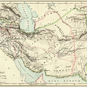
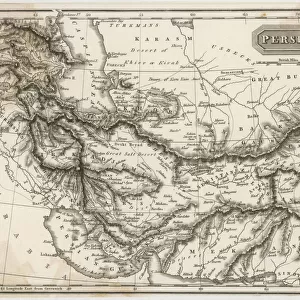
Fine Art Print : Persian Empire about 500 BC


![]()
Fine Art Prints from North Wind
Persian Empire about 500 BC
Map of the Persian Empire under Darius I, with principal satrapies, about 500 BC.
Color lithograph reproduction of a 19th-century illustration
North Wind Picture Archives brings history to life with stock images and hand-colored illustrations
Media ID 5877766
© North Wind Picture Archives
6th Century Bc Africa Ancient Ancient Civilization Ancient Greece Ancient History Ancient Persia Antiquity Asia Minor Assyria Babylonia Civilization Classical Classical Civilization Egypt Europe Greece Greek India Iran Mediterranean Sea Mid East Middle East North Africa Persia Persian Syria 500bc Armenia Darius Darius The Great Medea Persian Empire
A2 (42x59cm) Fine Art Print
Step back in time with our exquisite Fine Art Print from Media Storehouse, featuring a captivating image of the Persian Empire during the reign of Darius I around 500 BC. This stunning color lithograph reproduction, sourced from North Wind Picture Archives, showcases an intricately detailed map of the empire's principal satrapies. Transport yourself to ancient Persia and adorn your walls with this magnificent piece of history. Perfect for history enthusiasts, educators, and those who appreciate the beauty and complexity of ancient civilizations.
Our Fine Art Prints are printed on 100% acid free, PH neutral paper with archival properties. This printing method is used by museums and art collections to exhibit photographs and art reproductions. Hahnemühle certified studio for digital fine art printing. Printed on 308gsm Photo Rag Paper.
Our fine art prints are high-quality prints made using a paper called Photo Rag. This 100% cotton rag fibre paper is known for its exceptional image sharpness, rich colors, and high level of detail, making it a popular choice for professional photographers and artists. Photo rag paper is our clear recommendation for a fine art paper print. If you can afford to spend more on a higher quality paper, then Photo Rag is our clear recommendation for a fine art paper print.
Estimated Image Size (if not cropped) is 59.4cm x 37.2cm (23.4" x 14.6")
Estimated Product Size is 59.4cm x 42cm (23.4" x 16.5")
These are individually made so all sizes are approximate
Artwork printed orientated as per the preview above, with landscape (horizontal) orientation to match the source image.
FEATURES IN THESE COLLECTIONS
> Africa
> Egypt
> Related Images
> Africa
> Related Images
> Arts
> Artists
> S
> Syrian Syrian
> Asia
> Armenia
> Related Images
> Asia
> India
> Related Images
> Asia
> Iran
> Related Images
> Maps and Charts
> Early Maps
> North Wind Picture Archives
> Ancient history
> North Wind Picture Archives
> Maps
EDITORS COMMENTS
This print showcases a color lithograph reproduction of a 19th-century illustration depicting the Persian Empire around 500 BC. The map, under the reign of Darius I, displays the principal satrapies that constituted this ancient civilization. The image takes us on a journey through time, unveiling the vast expanse and influence of the Persian Empire during its peak. From Egypt to Greece, from India to Syria, Armenia to Babylonia, this empire stretched across continents and left an indelible mark on history. With intricate details and vibrant colors, this vintage artwork transports us back to an era where classical civilizations thrived in harmony with their surroundings. It offers a glimpse into the rich tapestry of cultures that flourished under Persian rule. As we explore this visual masterpiece further, we are reminded of the significant role played by Persia in shaping ancient history. Its reach extended from Africa to Europe and encompassed regions like Asia Minor and Parthea. This print serves as a testament to the grandeur and legacy of Darius I's reign as well as his title "Darius the Great". It encapsulates not only political boundaries but also cultural exchanges along trade routes connecting diverse peoples across lands surrounding the Mediterranean Sea. A true treasure for history enthusiasts or anyone fascinated by ancient civilizations; it invites us to reflect upon our shared human heritage while marveling at Persia's enduring impact on our world today.
MADE IN THE UK
Safe Shipping with 30 Day Money Back Guarantee
FREE PERSONALISATION*
We are proud to offer a range of customisation features including Personalised Captions, Color Filters and Picture Zoom Tools
SECURE PAYMENTS
We happily accept a wide range of payment options so you can pay for the things you need in the way that is most convenient for you
* Options may vary by product and licensing agreement. Zoomed Pictures can be adjusted in the Basket.