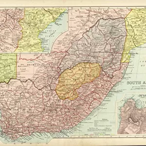
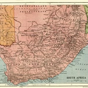
Fine Art Print : Pte Josiah Egerton Hills undated map of South Africa


![]()
Fine Art Prints from Mary Evans Picture Library
Pte Josiah Egerton Hills undated map of South Africa
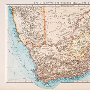
Copy of Pte Josiah Egerton Hills undated map of South Africa, showing the route taken by the South Nottinghamshire Yeomanry. Date: 1900
Mary Evans Picture Library makes available wonderful images created for people to enjoy over the centuries
Media ID 14389877
© The National Army Museum / Mary Evans Picture Library
Boer Copy Egerton Josiah Nottinghamshire Ranks Route Undated Yeomanry
A2 (42x59cm) Fine Art Print
Discover history through the lens of time with our exquisite selection of Fine Art Prints from Media Storehouse. This captivating piece showcases an undated map of South Africa by Pte Josiah Egerton Hills, acquired from Mary Evans Prints Online. The map, dated 1900, offers a unique glimpse into history as it illustrates the route taken by the South Nottinghamshire Yeomanry during their service. Each print is meticulously reproduced to preserve the original's intricate details and vibrant colors, making it a stunning addition to any home or office. Bring history to life with our Fine Art Prints - order yours today!
Our Fine Art Prints are printed on 100% acid free, PH neutral paper with archival properties. This printing method is used by museums and art collections to exhibit photographs and art reproductions. Hahnemühle certified studio for digital fine art printing. Printed on 308gsm Photo Rag Paper.
Our fine art prints are high-quality prints made using a paper called Photo Rag. This 100% cotton rag fibre paper is known for its exceptional image sharpness, rich colors, and high level of detail, making it a popular choice for professional photographers and artists. Photo rag paper is our clear recommendation for a fine art paper print. If you can afford to spend more on a higher quality paper, then Photo Rag is our clear recommendation for a fine art paper print.
Estimated Image Size (if not cropped) is 52.8cm x 42cm (20.8" x 16.5")
Estimated Product Size is 59.4cm x 42cm (23.4" x 16.5")
These are individually made so all sizes are approximate
Artwork printed orientated as per the preview above, with landscape (horizontal) orientation to match the source image.
EDITORS COMMENTS
This intriguing map, a copy of an undated work by Pte. Josiah Egerton Hills, offers a unique glimpse into the South African campaign during the Boer War of 1900. The map meticulously charts the route taken by the South Nottinghamshire Yeomanry, a British Imperial Yeomanry regiment, as they traversed the rugged terrain of South Africa. The South Nottinghamshire Yeomanry, a part-time military force, played a significant role in the Second Boer War, which lasted from 1899 to 1902. The conflict arose from tensions between the British colonial authorities and the two independent Boer states, the Transvaal and the Orange Free State. The Boer farmers, or Afrikaners, resented British encroachment on their lands and sought independence. Pte. Josiah Egerton Hills, a member of the South Nottinghamshire Yeomanry, created this map to document the regiment's journey through South Africa. The map includes various towns, rivers, and geographical features, providing a valuable historical record of the region. The route begins in the northern Cape Colony and heads southwards, passing through towns such as Bloemfontein, Winburg, and Brandfort. The map also includes various military camps and engagements, such as the Battle of Magersfontein and the Battle of Belmont, where the South Nottinghamshire Yeomanry participated. The regiment's involvement in these battles underscores the importance of this map as a primary source for understanding the military strategy and tactics employed during the Boer War. The map's intricate detail and accuracy reflect the meticulous planning and execution required for a successful military campaign. The South Nottinghamshire Yeomanry's journey, as depicted on this map, is a testament to the bravery and determination of the British forces during the Boer War. This rare and fascinating map provides a valuable insight into a pivotal moment in South African and imperial history.
MADE IN THE UK
Safe Shipping with 30 Day Money Back Guarantee
FREE PERSONALISATION*
We are proud to offer a range of customisation features including Personalised Captions, Color Filters and Picture Zoom Tools
SECURE PAYMENTS
We happily accept a wide range of payment options so you can pay for the things you need in the way that is most convenient for you
* Options may vary by product and licensing agreement. Zoomed Pictures can be adjusted in the Basket.