Fine Art Print > Europe > United Kingdom > Wales > Maps
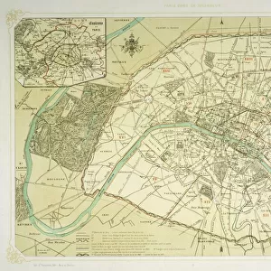
Fine Art Print : Maps / Australia 1854


![]()
Fine Art Prints from Mary Evans Picture Library
Maps / Australia 1854
Victoria, New South Wales, South Australia
Mary Evans Picture Library makes available wonderful images created for people to enjoy over the centuries
Media ID 571758
© Mary Evans Picture Library 2015 - https://copyrighthub.org/s0/hub1/creation/maryevans/MaryEvansPictureID/10004467
A2 (42x59cm) Fine Art Print
Discover the captivating beauty of history with our Fine Art Prints from Media Storehouse, featuring this exquisite map of Australia from Mary Evans Picture Library, dated 1854. This intricately detailed representation of Victoria, New South Wales, and South Australia is a must-have for history enthusiasts, geography buffs, and art collectors alike. Transport yourself back in time as you explore the rich history and cultural significance of this iconic map. Each print is meticulously produced using high-quality materials and vibrant colors, ensuring a stunning addition to any home or office space. Order yours today and bring a piece of the past into your world.
Our Fine Art Prints are printed on 100% acid free, PH neutral paper with archival properties. This printing method is used by museums and art collections to exhibit photographs and art reproductions. Hahnemühle certified studio for digital fine art printing. Printed on 308gsm Photo Rag Paper.
Our fine art prints are high-quality prints made using a paper called Photo Rag. This 100% cotton rag fibre paper is known for its exceptional image sharpness, rich colors, and high level of detail, making it a popular choice for professional photographers and artists. Photo rag paper is our clear recommendation for a fine art paper print. If you can afford to spend more on a higher quality paper, then Photo Rag is our clear recommendation for a fine art paper print.
Estimated Product Size is 59.4cm x 42cm (23.4" x 16.5")
These are individually made so all sizes are approximate
Artwork printed orientated as per the preview above, with landscape (horizontal) orientation to match the source image.
FEATURES IN THESE COLLECTIONS
> Europe
> United Kingdom
> Wales
> Maps
> Europe
> United Kingdom
> Wales
> Posters
> Europe
> United Kingdom
> Wales
> Related Images
> Maps and Charts
> Early Maps
> Maps and Charts
> Related Images
> Maps and Charts
> Wales
> Oceania
> Australia
> Related Images
> Mary Evans Prints Online
> Maps
EDITORS COMMENTS
This stunning print captures a piece of history with detailed maps of Australia from 1854. The intricate borders and labels showcase the regions of Victoria, New South Wales, and South Australia during this significant time period. Each line on the map tells a story of exploration, colonization, and growth in these Australian territories.
The rich colors and fine details in this print bring to life the vast landscapes and diverse topography that make up these states. From the rugged coastlines to the sprawling plains, every inch of land is meticulously depicted in this historical document.
As we gaze upon these maps from over a century ago, we are transported back in time to an era when Australia was still being discovered and settled by European explorers. The names of towns and cities may have changed since then, but the essence of each region remains preserved in these beautifully crafted illustrations.
Whether you have a personal connection to Australia or simply appreciate its unique history, this print is sure to captivate your imagination and spark your curiosity about the past. Display it proudly in your home or office as a reminder of how far this great nation has come since 1854.
MADE IN THE UK
Safe Shipping with 30 Day Money Back Guarantee
FREE PERSONALISATION*
We are proud to offer a range of customisation features including Personalised Captions, Color Filters and Picture Zoom Tools
SECURE PAYMENTS
We happily accept a wide range of payment options so you can pay for the things you need in the way that is most convenient for you
* Options may vary by product and licensing agreement. Zoomed Pictures can be adjusted in the Basket.