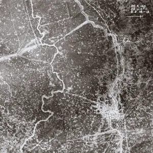
Fine Art Print : Aerial view near Kemmel, West Flanders, Belgium, WW1


![]()
Fine Art Prints from Mary Evans Picture Library
Aerial view near Kemmel, West Flanders, Belgium, WW1
Aerial view of a shelled area south-east of Kemmel Hill, a front line area near Ypres, West Flanders, Belgium, on 8 May 1918. Date: 1918
Mary Evans Picture Library makes available wonderful images created for people to enjoy over the centuries
Media ID 14415191
© The Patricia Aubrey Collection / Mary Evans
Auerbach Belgian Corps Fields Harold Observation Reconnaissance Roads Squadron
A2 (42x59cm) Fine Art Print
Experience the poignant history of World War I with our Fine Art Print from Media Storehouse, featuring an aerial view of the battlefield near Kemmel, West Flanders, Belgium. This evocative image, sourced from Mary Evans Prints Online, captures the devastating impact of the conflict on 8 May 1918. The shelled area south-east of Kemmel Hill, a front line area near Ypres, is a poignant reminder of the sacrifices made during this historic period. Add this beautiful and thought-provoking print to your collection and bring a piece of history into your home or office.
Our Fine Art Prints are printed on 100% acid free, PH neutral paper with archival properties. This printing method is used by museums and art collections to exhibit photographs and art reproductions. Hahnemühle certified studio for digital fine art printing. Printed on 308gsm Photo Rag Paper.
Our fine art prints are high-quality prints made using a paper called Photo Rag. This 100% cotton rag fibre paper is known for its exceptional image sharpness, rich colors, and high level of detail, making it a popular choice for professional photographers and artists. Photo rag paper is our clear recommendation for a fine art paper print. If you can afford to spend more on a higher quality paper, then Photo Rag is our clear recommendation for a fine art paper print.
Estimated Product Size is 59.4cm x 42cm (23.4" x 16.5")
These are individually made so all sizes are approximate
Artwork printed orientated as per the preview above, with landscape (horizontal) orientation to match the source image.
EDITORS COMMENTS
This evocative aerial photograph, taken on May 8, 1918, provides a haunting glimpse into the devastating impact of World War I on the rural landscape near Kemmel Hill in West Flanders, Belgium. The image, captured by the Royal Flying Corps (RFC) during the closing stages of the war, reveals a shelled area south-east of the hill, which was a front line position near Ypres. The once tranquil fields and countryside, dotted with roads and farmsteads, have been transformed into a desolate expanse of destruction. The RFC undertook regular aerial reconnaissance flights during the conflict to gather intelligence on enemy positions and movements. The use of military aviation revolutionized warfare, offering commanders a bird's-eye view of the battlefield and enabling them to make informed strategic decisions. The photo, taken by an unidentified RFC pilot, shows the aftermath of an intense artillery barrage. The scorched earth and cratered landscape bear testament to the brutal intensity of the fighting. The roads and fields, now reduced to a maze of pockmarks and rubble, serve as a poignant reminder of the human cost of war. This haunting image, taken during the 1910s, offers a unique perspective on the realities of the First World War, revealing the devastating consequences of the conflict on the Belgian countryside and the lives of those who inhabited it.
MADE IN THE UK
Safe Shipping with 30 Day Money Back Guarantee
FREE PERSONALISATION*
We are proud to offer a range of customisation features including Personalised Captions, Color Filters and Picture Zoom Tools
SECURE PAYMENTS
We happily accept a wide range of payment options so you can pay for the things you need in the way that is most convenient for you
* Options may vary by product and licensing agreement. Zoomed Pictures can be adjusted in the Basket.