Fine Art Print > Maps and Charts > Related Images
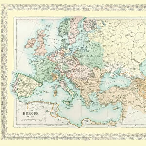
Fine Art Print : Map of Europe showing how it appeared after the Peace of Westphalia 1648AD


![]()
Fine Art Prints from MapSeeker
Map of Europe showing how it appeared after the Peace of Westphalia 1648AD
EHIST009
Welcome to the Mapseeker Image library and enter an historic gateway to one of the largest on-line collections of Historic Maps, Nostalgic Views, Vista's and Panorama's from a World gone by.
Media ID 20348258
Europe Europe Map Map Of Europe
A2 (42x59cm) Fine Art Print
Step back in time with our exquisite Fine Art Print from Media Storehouse, featuring a captivating Map of Europe as it appeared post-Peace of Westphalia in 1648AD, as seen in the MapSeeker collection. This intricately detailed and historically significant print is a must-have for history enthusiasts and art collectors alike. Bring the rich tapestry of European history into your home or office, and relive the pivotal moments that shaped our world. Order your Fine Art Print today and let the story unfold.
Our Fine Art Prints are printed on 100% acid free, PH neutral paper with archival properties. This printing method is used by museums and art collections to exhibit photographs and art reproductions. Hahnemühle certified studio for digital fine art printing. Printed on 308gsm Photo Rag Paper.
Our fine art prints are high-quality prints made using a paper called Photo Rag. This 100% cotton rag fibre paper is known for its exceptional image sharpness, rich colors, and high level of detail, making it a popular choice for professional photographers and artists. Photo rag paper is our clear recommendation for a fine art paper print. If you can afford to spend more on a higher quality paper, then Photo Rag is our clear recommendation for a fine art paper print.
Estimated Image Size (if not cropped) is 50.4cm x 42cm (19.8" x 16.5")
Estimated Product Size is 59.4cm x 42cm (23.4" x 16.5")
These are individually made so all sizes are approximate
Artwork printed orientated as per the preview above, with landscape (horizontal) orientation to match the source image.
FEATURES IN THESE COLLECTIONS
> Maps and Charts
> Related Images
> MapSeeker
> Maps of Europe
> Old Maps of Europe and Small Islands of
EDITORS COMMENTS
This print showcases a historical treasure, the "Map of Europe showing how it appeared after the Peace of Westphalia in 1648 AD". A true testament to the transformative power of diplomacy, this map encapsulates a pivotal moment in European history. The Peace of Westphalia marked the end of the devastating Thirty Years' War, which had ravaged Europe for nearly three decades. This meticulously detailed map depicts the territorial boundaries and political landscape that emerged as a result of this landmark peace treaty. It offers an intriguing glimpse into a continent reshaped by negotiations and compromise. As we examine this map, we are transported back to an era when nations were grappling with complex religious conflicts and competing ambitions. The intricate cartography reveals not only borders but also cultural nuances and regional identities that have shaped Europe's rich tapestry. Beyond its historical significance, this print is a visual feast for geography enthusiasts and art lovers alike. Its vibrant colors bring life to each country's distinct shape while capturing our imagination with every contour and coastline. Whether displayed in classrooms or private collections, this MapSeeker photograph invites us to explore Europe's past through its geographical evolution post-Westphalian peace. It serves as both an educational tool and a stunning piece of artwork that sparks curiosity about our shared heritage
MADE IN THE UK
Safe Shipping with 30 Day Money Back Guarantee
FREE PERSONALISATION*
We are proud to offer a range of customisation features including Personalised Captions, Color Filters and Picture Zoom Tools
SECURE PAYMENTS
We happily accept a wide range of payment options so you can pay for the things you need in the way that is most convenient for you
* Options may vary by product and licensing agreement. Zoomed Pictures can be adjusted in the Basket.