Fine Art Print > Arts > Artists > O > Oceanic Oceanic
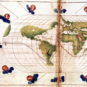
Fine Art Print : MAGELLAN: MAP, 1519-1522. Map of the Pacific Ocean showing Ferdinand Magellans route, 1519-1522. Wood engraving, 19th century


Resolution may be poor at this size (117 DPI)
![]()
Fine Art Prints from Granger
MAGELLAN: MAP, 1519-1522. Map of the Pacific Ocean showing Ferdinand Magellans route, 1519-1522. Wood engraving, 19th century
Granger holds millions of images spanning more than 25,000 years of world history, from before the Stone Age to the dawn of the Space Age
Media ID 7515047
1519 1520 1521 1522 Age Of Discovery Magellan New World Pacific Ocean Portuguese Route
A2 (42x59cm) Fine Art Print
Discover the rich history of exploration with our exquisite Fine Art Print of Magellan's Pacific Ocean Map. This stunning 19th-century wood engraving, sourced from The Granger Collection, beautifully illustrates Ferdinand Magellan's groundbreaking journey around the world, completed between 1519 and 1522. Add this captivating piece to your home or office to ignite conversations and inspire wanderlust. A perfect addition to any room, this fine art print is a testament to the spirit of adventure and the enduring allure of the unknown.
Our Fine Art Prints are printed on 100% acid free, PH neutral paper with archival properties. This printing method is used by museums and art collections to exhibit photographs and art reproductions. Hahnemühle certified studio for digital fine art printing. Printed on 308gsm Photo Rag Paper.
Our fine art prints are high-quality prints made using a paper called Photo Rag. This 100% cotton rag fibre paper is known for its exceptional image sharpness, rich colors, and high level of detail, making it a popular choice for professional photographers and artists. Photo rag paper is our clear recommendation for a fine art paper print. If you can afford to spend more on a higher quality paper, then Photo Rag is our clear recommendation for a fine art paper print.
Estimated Image Size (if not cropped) is 59.4cm x 35.6cm (23.4" x 14")
Estimated Product Size is 59.4cm x 42cm (23.4" x 16.5")
These are individually made so all sizes are approximate
Artwork printed orientated as per the preview above, with landscape (horizontal) orientation to match the source image.
FEATURES IN THESE COLLECTIONS
> Arts
> Art Movements
> Renaissance Art
> Arts
> Artists
> O
> Oceanic Oceanic
> Europe
> Portugal
> Related Images
> Maps and Charts
> Related Images
> Maps and Charts
> World
EDITORS COMMENTS
This 19th-century wood engraving showcases a historical map of the Pacific Ocean, depicting Ferdinand Magellan's remarkable route from 1519 to 1522. The intricate details and craftsmanship of this print transport us back to the Age of Discovery, a time when brave explorers like Magellan set sail into uncharted territories in search of new worlds. The map highlights Magellan's ambitious journey as he navigated through treacherous waters and unknown lands, ultimately becoming the first explorer to circumnavigate the globe. It serves as a testament to his determination and unwavering spirit, forever etching his name in history. As we study this engraving, we are reminded of the significant role that transportation played during this era. Ships were not only vessels for travel but also symbols of power and exploration. They carried intrepid adventurers across vast oceans, connecting distant civilizations and opening up new trade routes. Magellan's expedition was particularly noteworthy because it represented Portuguese efforts to expand their influence beyond Europe. This Renaissance-era voyage marked an important milestone in European exploration by uncovering parts of the world previously unknown to Europeans. In today's modern world where technology has made global travel accessible at our fingertips, it is humbling to reflect on these early pioneers who embarked on perilous journeys with limited resources and knowledge. This stunning print allows us to appreciate their courage while celebrating human curiosity and our innate desire for discovery.
MADE IN THE UK
Safe Shipping with 30 Day Money Back Guarantee
FREE PERSONALISATION*
We are proud to offer a range of customisation features including Personalised Captions, Color Filters and Picture Zoom Tools
SECURE PAYMENTS
We happily accept a wide range of payment options so you can pay for the things you need in the way that is most convenient for you
* Options may vary by product and licensing agreement. Zoomed Pictures can be adjusted in the Basket.